WebText – GEOGRAPHY OF UTAH
Utah’s
LOCATION… Crossroads of the West
Chapter 1 of GEOGRAPHY of UTAH, DRAFT webtext by G. Atwood, 2012 (modified 2014)
use with professional courtesy and attribution including to original sources where indicated.
Subtitle:
Location,
location, location… why location matters.
BIG CONCEPTS (for example, these might be concepts you'd teach someone else if you wanted them to understand Utah's geography, or geogarphy of a particular place, a school, for example.
LOCATION is the first of the FIVE GREAT THEMES OF GEOGRAPHY
1 Location responds to the question of where... Where am I? Where is....? Location is always with respect to something...
2 Location with respect to the Equator matters
3 Location with respect to oceans matters
4 Location with respect to terrain matters
5 Location with respect to political boundaries matters
6 Maps model location (hard copy and digitally GIS). Atlases are collections of maps
7 You, too, can make an atlas
8 Geography empowers!
FIRST... some EVIDENCE... time to work... actually play... with Google Earth, a favorite of geographers of Utah and elsewhere
LINK to image source: Google Earth... and locate Utah
LINK to NASA-WorldAtNight luminosity source NASA
LINK to image Dark Sky Earth source NASA
LINK to USA Dark Sky USA with borders, Source Dark Sky website
LINK negative of Night Sky, source Dark Sky website
LINK to NASA image of The Blue Marble
LINK to UGS (old, simple map) State of Utah; showing counties labeled and not labled
LINK to image of bas relief on LDS Church Office Building, Image of both bas reliefs, (not posted, need to add these images).
Quotation:
Tobler’s First Law of Geography = “Everything is related to everything else, but near things are more related than distant things,” Tobler, W., 1970. “A computer movie simulating urban growth in the Detroit region,” J. of Economic Geography, v. 46, n. 2, p 234-240.
Cases:
Brigham Young, on entering the Salt Lake Valley did not say… "Oh good, this is the LOCATION." He is reported to have said...
However, when he placed his staff where the St George Temple would be built... he may have said... "THIS is the LOCATION."
Crossroads Center is right downtown in SLC... why would it be called that?
West Valley City? West Jordan? North Salt Lake?
Topics… Questions
to Ponder –
Real estate agents chant “location, location, location.” What are they talking about?
How, and why, would Utah be a different PLACE if it were it located where Iowa is located, or Peru?
Within Utah… do Utah counties differ simply due to their location? LINK to map of Utah’s counties.
Overarching Goal
of the Chapter:
After studying the material of this chapter, students will be able to articulate why LOCATION is the first great theme of geography and what it means to (a) Utah and (b) to places within Utah.
By the end of this
chapter… you should:
Be able to locate Utah on a totally blank globe, and explain your rationale.
Understand at least three ways the location of a place can be defined, AND define Utah’s location using those three ways.
Understand where Utah is… with respect to the equator, with respect to oceans, with respect to terrain, and with respect to political boundaries, and hypothesize why Utah’s location with respect to those features matter.
Understand what an atlas is… and understand the logic behind the Atlas for a Utah School project.
Coaching: Memorize the Five Themes of Geography. (Location, Place, Migration/Movement, Interaction, and Region).
Coaching: Memorize Utah’s geographic boundaries by north-south latitude and east-west longitude (5 degrees by 5 degrees); and the states that are adjacent to Utah (all 6 of them); and start learning the location and names of Utah’s 29 counties.
MAJOR CONCEPT:
LOCATION is the first and foremost of the “five themes of geography” the others being (2) place; (3) migration / movement; (4) interaction; and (5) region. LINK to the course summary. Geographers recognize that everything is related to everything, however, as Tobler’s First Law of Geography observes: "Everything is related to everything else, but near things are more related than distant things" (Tobler, 1970, J of Economic Geography). As geographers study webs of relationships of physical and human geography, we study them in the context of space, using relationships of location.
Some TERMS:
These terms may be on the mid-term (use your own words) or on quizzes
LINK to terms list about Utah's geography... and useful for sense of place for other places as well.
Geography Is... LINK Source National Geographic
Location
Latitude
Longitude
Mid-latitude
Continental
Earth
Google Earth
Conterminous US
US States
Utah counties
City
School district
School
Census tract
Topography
Contour
Terrain
Map
Atlas
Atlas for a Utah School Project
Some EVIDENCE /
OBSERVATIONS … within Utah and beyond Utah:
LINK - Utah-Centered world - Source- WSU-BYU-Greer Atlas of Utah - also in Craig/Carr Utah Atlas, p. 8.
With respect to Latitude: Utah is about midway from equator to North Pole. Key terms: mid-latitude; Equator; North Pole. Also recognize longitude and Greenwich Meridian. Additional terms: Earth, Google Earth
East: http://eoimages.gsfc.nasa.gov/images/imagerecords/57000/57723/globe_east_540.jpg
West http://eoimages.gsfc.nasa.gov/images/imagerecords/57000/57723/globe_west_540.jpg
With respect to oceans: Utah is far inland from oceans. Key terms: continental.
LINK to physiographic provinces of US - Source CB Hunt, used with permission. With respect to terrain: Utah is in the Intermountain West. Terms: Intermountain West, terrain, topography, contour (more on contours, later). More on Utah's 3 major physiographic provinces, later. LINK to Hunt modified.
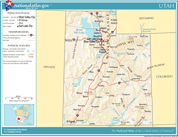
LINK With respect to the conterminous USA source Google Earth LINK to conterminous USA States not lableled LINK to states labeled Source USGS National Map Utah is at the center of western US. Terms: Crossroads of the West; conterminous US; US States; cities, interstate highways, cities. Not shown: school districts, schools, census tracts.
LINK Utah with counties --Utah Map... helpful map to print out, Source UGS -- With respect to size: Utah is approximately 5 degrees wide (114 - 109 degrees west of the Greenwich Meridian (aka the Prime Meridian) and 5 degrees tall (from 37 degrees north to 42 degrees north of the Equator). The state measures about 270 miles east west across mid-state; and 350 north south (to 42 degrees north). (Geography question... if Utah is 5 degrees by 5 degrees, why is it thinner east-west than north-south?)
Some THEORY /
CONCEPTS concerning location:
Concept #1--
Location answers the question… where is… Location is always with respect to something... generally with respect to something
physical. Geographers call it… “spatial referencing.”
LINK Milky Way galaxy - Source NASA-JPL
LINK Milky Way annotated - Source NASA - JPL
LINK Earth is located in solar system - Source NASA
LINK North American continent - Source Google Earth
LINK Conterminous USA Source USGS National Atlas
LINK in the Western US Source USGS National Atlas
LINK in Salt Lake County Source National Atlas
LINK in Salt Lake City Source Google Earth
LINK Salt Lake City, east bench Source Bowen (with permission)
LINK Salt Lake - Davis counties border, source Google Earth
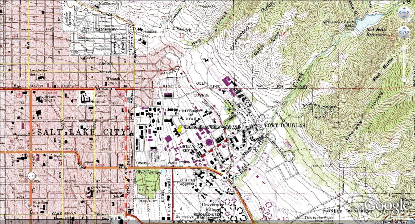
LINK UofU within topo map, Source USGS topo map Fort Douglas Sheet
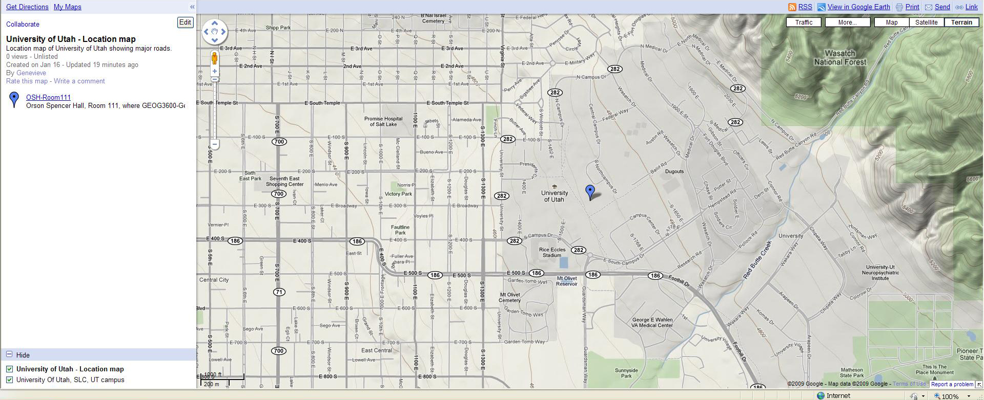
LINK University of Utah, source Google Maps
LINK Orson Spencer Hall (GeogDept UofU) and Marriott Library, Source Google Earth
LINK Room 1008 Marriott Library Source, Campus Map
Where am I... in universe, in Milky Way galaxy, along one of its shorter arms, in solar system, on Earth, on North American continent, in the conterminous United States of America, in the western US, in Utah, in Salt Lake County, in Salt Lake City, on the East Bench or University area of Salt Lake Valley, on the University of Utah campus, at Marriott Library.
For purposes of Geography of Utah… location refers (a) to Earth’s surface or near-surface, and (b) is defined by the context of other features or imaginary grids. These reference places can be points (such as survey points); lines / grids (such as latitude-longitude), or areas (for example, states, watersheds, or physiographic regions).
Location with respect to something can be self-centered, for example, left or right… or the radial distance from a place. For example, the world from a Utah-centered perspective. Craig/Carr Atlas of Utah p. 8; Greer, 1981, Atlas of Utah, p. 4. Or with respect to a specific place that can be measured from several places on Earth to establish a point to measure from: LINK Hudson Laying out Base Line Source Stansbury, expedition of the 1860s. Fremont's map of 1840s of GSL also used "triangulation" (geometry using angles) siting from islands and mainland peaks to make a rough map of Great Salt Lake. Trilateration (geometry) uses distance, rather than angles, from several places if their locatioin is known such as GPS units locating themselves via distance to GPS satellites LINK to 24 satellite configuration Source Trimble Navigation... and now there are many more satellies to reference by.
CASE of interest: What did the LDS pioneers do without topo maps??
Location can be with respect to an arbitrary grid, for example, the early pioneers could not drop into the local USGS office and buy a topo map. They set up a grid using an arbitrary grid based on cardinal directions (north, south, east, and west). LINK to Salt Lake City - UofU - Fort Douglas USGS Quad showing Salt Lake Base line... who has not been there who lives in Utah? Where is the point of origin? Put it on your "places in Utah" check list! LINK to topo map Source USGS; LINK to image of survey point of origin, needed.
It can be with respect to the geographic grid, the system of latitude and longitude. Utah lies between 37 and 42 degrees north latitude and 114 and 109 degrees west longitude. LINK to geographic grid Source Google Earth
Concept #2: Location with respect to the Equator matters.
LINK Global geographic grid, Source Google Earth
LINK gridded by degrees, source needed
LINK Average Temperature ranges, Source Google Earth, NASA, Christofferson
LINK Geographic Grid for Utah, Source Google Earth
Location with respect to the equator affects amount and intensity of sunlight reaching Earth’s surface and, therefore, seasonality. Utah’s location, approximately half way between the Equator and North Pole puts Utah in the mid-latitudes with four seasons. This affects both Utah’s physical and human geographies. Consider the implications to Utah’s economy, to Utah climate… etc.
LINK Longitude and Time Zones source Google Earth
WebLink: http://tycho.usno.navy.mil/tzones.html
Does Utah’s location with respect to longitude impact Utah’s physical or human geographies? Longitude does not cause physical changes the way latitude causes seasonality. It could be argued that human geographies are affected by differences in longitude, such as time zones. Utah is about one third of the way west around the globe from 0 degree longitude, the arbitrarily chosen prime meridian that crosses through Greenwich England. The Brits earned it! Utah is approximately opposite to Australia.
Concept #3: Location with respect to oceans
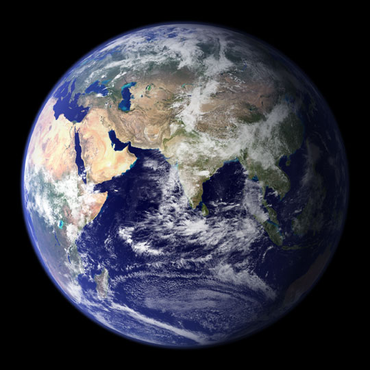
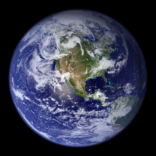
LINK Earth... the Blue Marble Source NASA
LINK US precipitation ... UT precipitation Source DNR Water Plan
Compare... LINK US-Mean Annual Precipitation versus Mean Air Temp - Source NOAA
Location with respect to oceans directly affects weather / climate and therefor indirectly affects diverse aspects of physical and human geographies. Biota depend on precipitation. Coastal communities may be vulnerable to hurricanes. Weather patterns “born” over oceans differ markedly from those over continental masses. Utah is inland from oceans and this aspect of location affects the timing and nature of precipitation, vulnerability to drought, and sensitivity to changes in climate.
Concept #4:
Location with respect to terrain matters… elevation itself matters.
LINK Map of North America
LINK Sterner DEM of Utah source Ray Sterner, Fermi Lab, used with permisison
LINK Satellite image of Utah; source WSU/BYU/Greer Atlas of Utah p 6;
LINK Vegetative Zones key; source WSU/BYU/Greer Atlas of Utah p 30
Whether a place is high or low in elevation, or in a region of high or low relief (difference in elevation between two places), or in mountains versus lowlands affects aspects of human and physical geography such as wind patterns; migration / transportation routes; the courses of streams; property values; and even patterns of some diseases. Utah is located east of the Sierra Mountains and west of the Rocky Mountains. (Note: there is a difference between the “Rocky Mountains” and the “Rocky Mountain physiographic region.” The place name, Rocky Mountains, refers to only part of the province, the part that is centered in the high country of Colorado… indeed this can be confusing. Utah’s location between these mountainous features has affected human geography (early settlers a psychological sense of isolation) as well as physical geography such as water resources and associated agriculture.
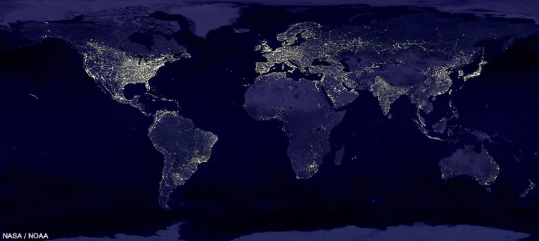
LINK Night sky image negative- source of positive, Dark Sky website. Within Utah, terrain matters. Are the cities of Utah randomly distributed? This image shows a portion of Earth at night, Utah and its environs. The image is from the Dark Sky website and includes state borders. Locate Las Vegas... and St George… Grand Junction, CO. Now locate the Wasatch front is pretty easy... how about Great Salt Lake. Don't assume all bright places are communities. For example, what are the bright spots in northwestern Utah? If we were in Africa or South America... similar points of light might be agricultural burnings... what would flare in southwestern Wyoming and northeastern Utah?
Concept #4:
Location with respect to political boundaries matter:
LINK North America
LINK United States of America
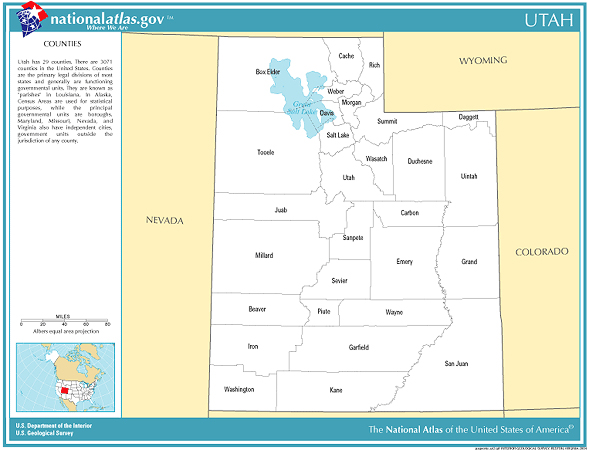
LINK Utah counties – 29 of them - Source UGS - LINKED to named; LINKED to without names
LINK Salt Lake County's communities
LINK US States, conterminous; LINK Intermountain states
LINK to The 15 Words of GEOG3600
Location with respect to political boundaries affects personal identity (psychology); social institutions (sociology); economics; the web of relationships of human geography.
Utah is a relatively large state by surface area about 85,000 square miles (84,094 sq. mi. (acc Netstate) making it the 13th largest in the nation.
Utah is located in the Intermountain West and Salt Lake City has been called the Crossroads of the West, with reason if one looks at a map. Utah shares boundaries with 6 states. Consider Tobler’s First Law of Geography’s implications for interstate trade, immigration LINK, or even for the sourcing of UofU freshmen LINK.
Concept #5: Maps
are models of location. GIS (Geographic Information Systems) is a toolbox for
making spatially referenced models.
LINK
LINK
LINK
For a geographer, if a picture is worth a thousand words, a map is worth ten thousand words. Maps are “models” … models of LOCATION. Maps (including digital maps such as GIS models) are the geographers medium of communication. Maps are to geographers as scissors are to a hair stylist; scores are to an orchestra, pots/pans/oven/dishwasher... and entire kitchen... to a cook. Twentieth century geography has been revolutionized by the digital world. If you’re not familiar with GIS (Geographic Information Systems), know that it spells “job” for many majors in departments of geography. The University of Utah’s program is strong academically (research in time and space such as transportation models) and is practical (the certificate in GIS). LINK
A digression…
The term “scale” can be confusing. A map’s scale is a ratio that quantifies the size of the map depiction to the size of the land depicted. A 1:24,000 scale map means an inch on the map represents 24,000 inches of distance in reality. The confusion is that a small scale map covers a large area. A small scale map fits on small piece of paper compared to a large scale map. This text generally uses “fine” scale and “coarse” scale to avoid confusion.
Geography of Utah will examine many maps. Some maps are reference maps, meaning, they are intended to show location, for example a highway map shows the location of highways and cities and some prominent features. A street map shows streets. Other maps are thematic maps, meaning, they are intended to show relationships such as land use or population density.
Concept #6: An
atlas is a collection of maps
LINK Atlas of Utah by WSU/BYU/Greer image of cover and image of page - elevation
LINK Benchmark Atlas of Utah cover image of atlas; maps within show location and relief (slope and elevation)
LINK Historical Atlas of Mormonism cover, Brown et at, 1994 and LINK detail of page set
LINK Different widths and hefts, Source GA
An atlas is a collection of maps, generally with some text, and almost always with a purpose to pull together geographic information about a place. Some atlases are fat, some are thin. Some are now digital.
Maps that primarily show location are called “reference” maps. Entire atlases can be reference maps. The Benchmark Atlas for Utah is an atlas of reference maps. Its purpose is to provide abundant information about location of features that can be recognized in the field. Its moderate scale is perfect for recognizing features as one drives from place to place in Utah.
Some atlases have location maps and maps on specific theme or topic. The BYU/Greer, 1980, Atlas of Utah is all about Utah. It has a few reference maps and many thematic maps. It continues to be useful, although it is out of print and, with respect to human geography, out of date. Craig and Carr, 2008, Utah Atlas: geography and history, is an abbreviated, useful, handy atlas with maps on a DEM base.
Atlases can have focused themes: The Historical Atlas of Mormonism LINK not only is focussed, it's format is rigorous: one map, one page of text. The New Historical Atlas of Religion in America, by Gaustad and Barlow (2001) has broader context and more flexible layout of map versus discussion LINK and much greater heft LINK.
Some books, exclusively about geography have no maps. They are not atlases. Van Cott’s (1977) Utah Place Names has one map. LINK to image of Place Names - by Van Cott; and LINK to random page. Utah Place Names is not an Atlas although it is all about locations, places, and history.
Concept #7: You, too, can make an atlas.
Here is the philosophy behind the Atlas project of the UofUtah's Geography of Utah. Let’s start with a mantra about empowerment. I adopted this approach from a wise USGS geologist (Walt Hays) while I was at the Utah Geological Survey and we wanted to empower people to prepare for Earthquakes in Utah…
Hays-Atwood mantra for empowerment:
· Before people are empowered to take action…
· They must hear the message…
· They must understand the message…
· They must personalize the message…
· And then there is a fighting chance they are empowered to take action.
The Atlas for a Utah School Project happens to be a genuine service project, several students a year post their atlas to the UofU website and the schools they have studied have used them. However, service is NOT its main objective. The main objective of the Atlas Project is to “personalize” concepts of the course. In Chapter 6 of this web-text, the geosphere, a major concept is the spatial distribution of Utah’s topography and how it affects scenery. Student atlases of the past have “personalized” the concept for “their school” at a neighborhood, city, or county scale. This web-text will discuss political geography, how Utah compares and contrasts to the Nation. Student atlases present information at a more detailed scale… of a county or census district. With classmates, digitally linked by Canvas in the University of Utah instructional system, discussion groups compare and contrast geographic patters, teaching one another concepts of human and physical geography. Atlas sections are defined to encourage (a) observation; (b) analysis using concepts from the web-text; and (c) critical thinking about webs of relationships among LINK to course summary. Some students have tired of their school by the end of the semester and in recent years, students study all of a county. By understanding contrasts among places even within a county, and across Utah, students can master the physical and human geography of Utah, meaning, think critically and with competence about the web of relationships among Utah's peoples, places and enviroments, the 15 themes.
Underpinning every chapter of this web text is my desire for students to succeed in the paths they choose to lead, including civic engagement. Having a “sense of place” is empowering. The Atlas project is meant to provide students with a sense of place for a place in Utah. My personal goal with this project is that every student, will be empowered by the knowledge and skills of Geography of Utah to make a positive difference to the world they entering. Location, location, location is the first chapter an Atlas for a Utah School.
Importance -- LOCATION and others of the 15 themes of Geography of Utah.
LINK Matrix of The 15 Words of GEOG3600.
LINK IHC Hospitals 1990s, Source IHC used with permission
How can "importance" be identified and discussed? There are many ways. Geography of Utah assumes that if "A" causes "B" ... or even if "A" influences "B" it is important. For purposes of Geography of Utah... if Theme "A" causes change of Theme "B" it is important. Identify causal relationships... and identify importance as far as this course is concerned.
Everything relates to everything… that is a recurring theme of geography, of Earth systems. Location matters to the physical and human geographies of Utah.
Let's discuss:
LOCATION - MOVEMENT and Utah
LOCATION - ATMOSPHERE (weather and climate) and Utah.
Which of the 15 themes of Geography of Utah is least affected by LOCATION?
How can this be visualized?
GEOG3600 studies “the five themes of geography” in part one; the five subsystems of Earth systems in part two and how they affect social and behavioral issues; and five themes of social and behavioral sciences. How everything affects everything can be expressed as a matrix… a 15 x 15 matrix.
To be specific, and to drill deeper into these effects, use the matrix and consider causal relationships. As the course evolves, each of “The 15 Words” will be a class session. For example: consider how location affects a sense of place; how location affects migration patterns; how location affects the economy of Utah. In considering these relationships, consider how location affects Utah with respect to other locations of the United States, or North America, or elsewhere. Also consider how areas within Utah differ because of their location. For example, Rich County in northern-most Utah has a different agrarian economic base than Washington County in Utah’s “Dixie.” The city of Wendover on the Utah-Nevada line has challenges of water that differ from those of Alta high in the Wasatch Range due to location with respect to terrain.