WebText-
GEOGRAPHY OF
Chapter 9 –
DRAFT
webtext by G. Atwood, 2012
Use
with professional courtesy and attribution including attribution of original
sources where indicated.
LINK
to printable version… it may differ a bit from this web-posted version.
CHECK
THIS
Subtitle:
BIG CONCEPTS: This chapter explores
1. The BIOSPHERE, the living
Earth, is a subsystem of Earth systems. Systems have subsystems that interact.
2. Regions of the BIOSPHERE
are difficult to draw. What bio-characteristic should be basis for distinction?
3. Biosphere basics… 101. Life
is awesome, global, regional, and local. Some concepts help explain spatial
variations
4. Bioregions… climate largely
determines bioregions. Location (first theme of geography) largely determines
climate.
5. Classifications based on ecoregions
can overwhelm by detail. Think big concepts of Earth systems.
6. Explorations of
7. Adaptation and biodiversity
result from
8. Urban ecosystems… elsewhere
and in
9. The human footprint … lots
of imprints across
EVIDENCE. Examine these images in
the context of zzzz.
Images
Quotation:
“We
can never do precisely one thing” G. Hardin
LINK
to The 15 Words of GEOG3600 and version that can be printed.
CASES:
Great Salt Lake, permission from Don Paul... champion of habitat, globally and locally LINK
Cryptogammic
soils
Prairie
dogs
Seagulls
and SL Landfill?
Topics… Questions to Ponder
–
How
have plants and animals (including humans) adapted to conditions of
What
has gone on in the ecosystems of
Overarching Goal of the
Chapter:
See,
understand, and appreciate that changes to the biosphere indicate changes to
Earth systems.
MAJOR CONCEPT:
All
plants and animals are in ecosystems. Ecosystems function in the context of
ecoregions, their setting. Their setting used to be called physical geography
and now is called Earth systems, the five we study in this part of Geography of
Utah. Expect
Addendum
/ clarification / expansion on the “major concept”…
As
physical geography of
Specifics: by the end of
this chapter… you should:
· Be able to explain how
· Understand that abiotic
components of the biosphere relate to subsystems of Earth systems, namely the
geosphere, hydrosphere, and biosphere.
· Be able to explain the
logic behind the EPA ecoregions map.
· Given the EPA ecoregions
map, and with access to the web, be able to assess locations in
· Given the EPA ecoregions
maps and maps that show terrain and temperature ranges, be able to explain why
area’s ecosystems differ, for example, why do the ecosystems of St George
(Washington County) differ from those of Rich County?
Coaching for students of
UofU GEOG3600-Geography of
Coaching #1: Do not feel obligated to
memorize
Coaching #2: Ask yourself “why” there
are more ecoregions than physiographic provinces and why ecoregions appear
disrupted.
Terms to understand with
respect to the BIOSPHERE
These
terms may be on the mid-term (use your own words) or on quizzes
Biosphere
Habitat
Niche
Flora
Fauna
Ecosystem
Ecoregion
Species
Biodiversity
Invasive
species
Wasatch
and
Colorado
Plateaus ecoregion
THEORY / CONCEPTS towards
an understanding of geography of
1. The BIOSPHERE, the living Earth, is a subsystem of Earth
systems. Systems have subsystems that interact.
IMAGES
Life
is a component of each of Earth’s subsystems and processes of those subsystems:
rock cycle, water cycle, chemical cycle, carbon cycle… Of course there are
feedback loops.
Are
humans part of the BIOSPHERE? Of course.
The
anthrosphere is the human footprint on Earth, our impact on our Planet. There
is great overlap between the biosphere and the anthrosphere. But also consider
how much overlap there is between the anthrosphere and atmosphere… and the
biosphere and atmosphere. The subsystems of Earth systems are interrelated with
feedback loops.
2. Regions of the BIOSPHERE are difficult to draw. What
bio-characteristic should be basis for distinction?
Zones
by elevation and by community:
LINK
Key to Atlas of Utah key to zones by elevation and community - WSU-BYU-Greer_Atlas of Utah p031 and map WSU-BYU-Greer_Atlas of Utah p 30, and ensuing pages (podcast).
LINK Ecoregions (EPA) displayed across ESE-DEM (base by Sterner); also in
Craig and Carr - Bailey's classification of ecoregions.
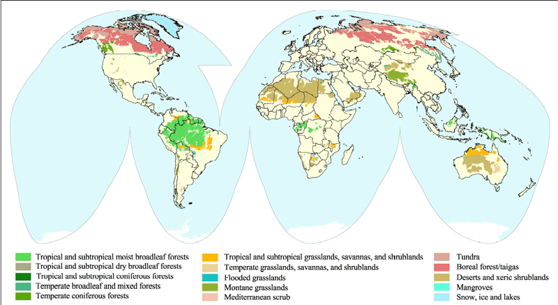
LINK Marietta-Global biomes; Marietta-US-Biomes;
LINK to OAK RIDGE 1000 ecoregions
of US... an experiment in how to use spatial clustering. Look at all the data!
Regions are meant to be relatively broad, relatively coherent, relatively continuous, and relatively similar within versus beyond with respect to a definable characteristic. For example, regions of the hydrosphere can be logically drawn based on watersheds and the regions are called drainage basins. Regions of the geosphere defined on the basis of landforms are called physiographic provinces. Contrasting broad areas based on landforms is more subjective that contrasting broad areas based on watersheds. Boundaries of physiographic provinces are more debated than boundaries of drainage basins. What about regions of the biosphere?
Does a dominant plant type serve the purpose? or large mammals? or small mammals? If not a species... a community of species, an assemblabe (biome)? or how about ecoregions based on a composite of physical factors and associated biota?
Reminder:
regions (meaning the process of defining regions) are meant to serve a purpose.
They provide shortcut communication of an array of information. When you hear a
region described as “steppe” you know
that a broad area has, generally, greater evaporation than precipitation but
not twice as much evaporation as precipitation. You’d picture a place such as
the Book Cliffs or the Grand Staircase… including its vegetation. You would not
picture
Reminder:
the process of defining regions is meant to make things simpler… for
communication of ideas, for management of resources, and for understanding
interactions. With respect to the biosphere… (a) simpler may be deemed too
simple. In the 1960s, classifications of the biosphere were based on elevation
and the plant communities generally found in elevation intervals. Elevation was
used as a “proxy” for plant communities. A proxy is a relatively-easily
measured factor that correlates with a factor one wants to classify, but a
factor that is difficult to define. Elevation is easily measured and it is
associated with plant communities world wide… in some areas more closely
associated than others. The “interaction” that underpins the association is
tree-response to terrain (geosphere: bedrock versus sediment; north versus
southern exposure) and associated seasonality, temperature, and available
moisture.
BIOME = Broad life zones. Biological communities with flora and fauna that have adapted to environments with similar conditions. Those conditions include climate, topography, and earth materials. Biomes are often named for a dominant vegetation species, e.g., grasslands, or environment, e.g., desert. Biomes indicate general associations of plants, animals, and… climate.
A
good site for biomes was:
http://www.marietta.edu/~biol/biomes/biome_main.htm LINK not functioning 2012.
With
time, definition of regions for the biosphere has become more complex… from
plant communities, to ecosystems, to ecoregions. The ecoregion approach of the
21st century includes a hierarchy of nested levels of detail from local to
regional. Local (Level IV) ecoregion definitions include variations based on
soils (geosphere); available moisture (hydrosphere); freeze/thaw and seasonality
(atmosphere); ecosystem communities (biosphere); and, to a lesser extent, human
impacts (anthrosphere). Regional (Level II) ecoregions resemble patterns of
Before
exploring the ecoregions of
3. Biosphere basics… 101. Life is awesome, global, regional, and
local. Some concepts help explain spatial variations.
ADD IMAGE (this chapter / lecture needs good illustrations... not-copyrighted images, such as from governmental sources) E
Life
is totally fascinating. Perhaps my favorite overview of “introductory biosphere” is
Trefil and Hazen, 2010, The Sciences, and
integrated approach. Several concepts are incorporated in this chapter, including their discussion of life and their approach to teaching.
Even
simple lifeforms are complex and “organized.”
Lifeforms
grow and reproduce. To do so, lifeforms need water and energy. Animals eat to
stay alive. They eat for energy. Ultimately that energy came from the sun (with
some exceptions such as: some primitive life forms gain energy from chemical
reactions with substrate; others fix energy from hydrothermal systems). Plants
fix energy from the sun; animals eat plants and gain energy; and some animals
eat animals (eventually tied back to plant sun-energy fixers). Energy flows
through biologic systems. Virtually all lifeforms rely on solar energy directly
or indirectly via food chains / food webs. Matter also flows through the
system. Plants fix carbon and other nutrients via the process of photosynthesis
using solar power. Animals eat to capture not simply calories but also
nutrients fixed by plants or other animals. Matter cycles through the system
from non-living, to living, to non-living. All lifeforms need water, some more
than others. So… energy, matter, and water cycle through life systems.
Ecosystems:
All living things can be studied in the context of systems (ecosystems) because
all living things exist in the context of an ecosystem. Ecosystems have abiotic
(non living components) and biotic (living) components. Although some
ecosystems can be thought of as stable or balanced, this does not mean they are
static. All animals have a niche and a habitat. Their habitat is, essentially,
where they live. Their niche is what they eat (their role in the ecosystem,
their job).
Webster-on-web…
· Habitat...”where a living
thing lives or grows, or commonly found.”
· Niche… “the ecological role
of an organism in a community especially in regard to food consumption”
Ecosystems
change as the local expression of Earth’s subsystems change, and those systems
change. Tectonics and erosion/deposition change the geosphere The biosphere
contributes to erosional/depositional processes. Terrain and climate change the
hydrosphere… and so does the biosphere, for example, eutrophicatoin. Ecosystems
are communities of living things, and as conditions change, the communities
change.
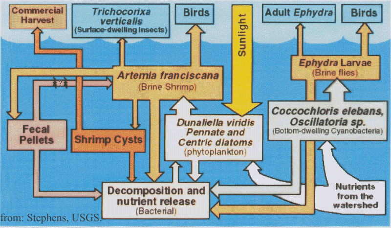
Case
history – GSL from Doyle Stevens USGS; and, Thank you Don Paul for the case history presentation…
10.
Bioregions… climate largely
determines bioregions. Location (first theme of geography) largely determines
climate.
IMAGE:
LINK
to Classifications based on "evapotranspiration, precipitation,
humidity... lead to latitudinal regions and altitudinal belts LINK
"HoldridgeLifeZones from UCSB web site.
SPATIAL
PATTERNS
As
geographers of
Five
themes of geography (Part I of this text) and the five subsystems of Earth
systems (Part II of this text), and even to examine issues of social /
behavioral science (Part III of this text).
As
geographers, we have perspectives about strategies of life. Organisms respond
to environment, to geography. How do we study geographic relationships? Some
studies of UofU geography graduate students include: studying bats, rats and
hanta virus (
11.
Classifications based on
ecoregions can overwhelm by detail. Think big concepts of Earth systems.
IMAGES
A
BIOREGION is a region tied to habitat.
A
BIOGEOGRAPHIC PROVINCE is larger than a BIOREGION.
ECOSYSTEMS
are systems of lifeforms that interacts. ECOSYSTEMS can be studied in the
context of regions, ECOREGIONS. The word, ecoregion, should inspire thoughts of
geography: interactions among the five subsystems of Earth systems. ECOREGIONS
put ECOSYSTEMS into the context of Earth systems, specifically, the geosphere,
hydrosphere, atmosphere, and anthrosphere… with feedback loops to the biosphere
itself..
ECOREGIONS
are similar to biogeographical provinces and emphasize ecosystem relationships.
For geographers of
Maps
of ECOREGIONS of
“Ecoregions of Utah” summarizes
ECOREGIONS:
definition from the World Wildlife Fund
An
ecoregion is defined as a large area of land or water that contains a
geographically distinct assemblage of natural communities that (a) share a large majority of their species
and ecological dynamics; (b) share similar environmental conditions, and; (c)
interact ecologically in ways that are critical for their long-term
persistence.
LINK
to Level I – EPA-ecoregions of
2
ecoregions #6 =
LINK
to EPA Level II – ecoregions of
2
ecoregions #6.2 = Forested areas of western Cordillera; #10.1 = Western interior
basins and ranges
LINK
to EPA-Level III - ecoregions N.Am ...LINK EPA-ecoregions-Level III - clip for
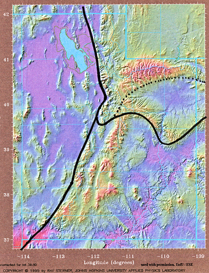
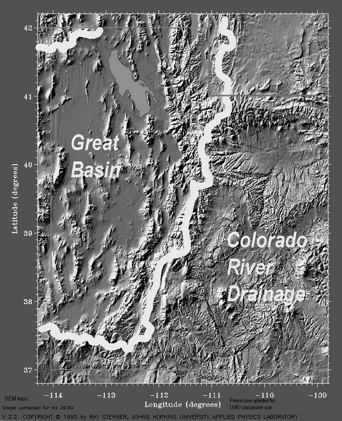
LINK
to EPA-Ecoregions of Utah - LEVEL IV... 8.5x11 page size - This map is a "keeper"... to detailed to memorize but page size and loaded with information.
Caution…
there’s a lot of geography here; and plenty of jargon to get hung up on,
especially soils jargon; but to move through that… Practice your skills as a geographer of Utah. What matters... so what... of the Earth systems covered in previous chapters, with respect to Utah's biosphere.
GEOSPHERE:
Materials
(bedrock versus sediment; perhaps what type of bedrock)
Landforms:
(mountains, plateaus, valleys, … )
Processes:
(tectonics; erosion/deposition)
HYDROSPHERE:
Processes:
the water cycle
Water
balance
Water
availability: Surface vs Ground water
Timing
of water availability: short term seasonal; long term e.g. drought
ATMOSPHERE
Evaporation;
Precipitation
Extremes:
freezes or not; how hot, how cold.
6. Explorations of
IMAGES
Should
you cite this information, please use the following CITATION for the poster:
Woods, A.J., Lammers, D.A.,
The verbiage below may confuse. I don't want you to slog through definitions at Level IIII. So I have quoted verbiage from Level III ... so you can appreciate broader patterns of Level IIII. I'll say that again. Level IIII ecoretions nest into Level III ecoregions that nest into Level II ecoregions that nest into Level l ecoregions. This map shows Level IIII regions, meaning many many subregions of Level III. The description of Level III regions summarizes the entire set of Level IIII regions within it. LINK to pdf of front of poster. and LINK to back of poster.
Images are from Hamblin, Beyond the Visible Landscape, BYU Geology, (permission given for teaching purposes)
The material below is quoted from the EPA poster... if you use this language, attribute the EPA source (citation above) not ESE website.
13.
Scene
from Hamblin-: p 227
“Comprising
the middle of three large ecological regions in the north-south oriented
intermontane basin and range area of the western
14-
MOJAVE – SOUTHERN BASIN AND RANGE - LINK map LINK Back
Scene
from Hamblin: p.129 -Virgin Anticline
This
arid ecological region encompasses the Mojave and
18.
Scene
from xxxx no Hamblin
Called
the
19.
WASATCH and
Scene
from Hamblin p 211 Uinta Mtns;
This
ecological region is composed of a core area of high, precipitous mountains
with narrow crests and valleys flanked in some areas by dissected plateaus and
open high mountains. The elevational
banding pattern of vegetation is similar to that of the
20.
COLORADO PLATEAUS LINK map; LINK back
Scene
from Hamblin p. 69 Waterpocket fold
Rugged
tableland topography is typical of this region, often referred to as the
Colorado Plateaus. Precipitous sidewalls
mark abrupt changes in local relief, often from 300 to 600 meters. The region is more elevated than the
21.
SOUTHERN ROCKIES LINK map; LINK back
No
scene from Hamblin (!)
This
region, referred to as the
80.
NORTHERN BASIN AND RANGE (modified) LINK map; LINK back
No
scene from Hamblin
Consists
of dissected lava plains, rolling hills, alluvial fans, valleys, and scattered
mountains. Although arid, it is higher and cooler than Ecoregion 12 (Snake
River Plain) and has more available moisture than Ecoregion 13 (
7.
Adaptation and biodiversity
result from
LINKS to a few EPA IMAGES of examples of flora and fauna by ecoregion (note to readers of this web page... this chapter needs good illustrations... please contribute non-copyrighted, images, identified including, if possible by location)
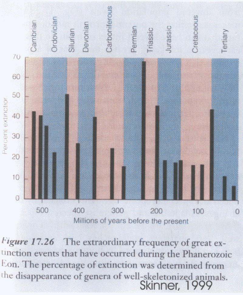
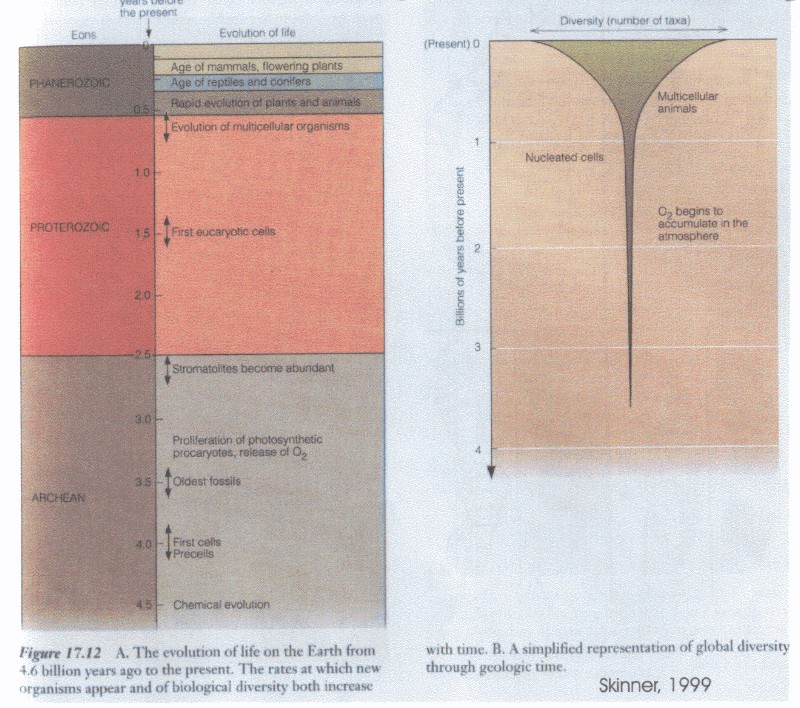
Biota have changed through time... LINK Skinner-numbers of species, extinctions,.
Ecosystems
adapt to biotic as well as physical conditions. A keystone species is a plant
or animal on which a pyramid of life forms depend. ___ the
BIODIVERSITY
refers to the variety of living things of an area or region… their genes, their
species, their habitats. It’s considered “good” or “healthy” to have diversity.
LINK Skinner-Biodiversity thorugh time. Harsh environments can function with few species so long as there are
“producers” and “scavengers.” Biodiversity is enhanced by boundaries among
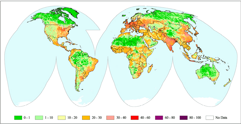
habitats. Utah not “rich” by global standards LINK WorldMap and Great Salt Lake
is remarkable by most standards for its (a) diversity in DNA; (b) however,
limited number of species; (c) numbers
of individuals.
LINK
to USGS site.
8.
Urban ecosystems… elsewhere
and in
IMAGE
Meadowlark
IMAGE Starling; rat;
IMAGE
Seagull –
Some
general concepts about cities… winners and losers in urban places… how do
organisms adapt?
Urban
ecosystems offer case histories of changed communities. Some organisms adapt.
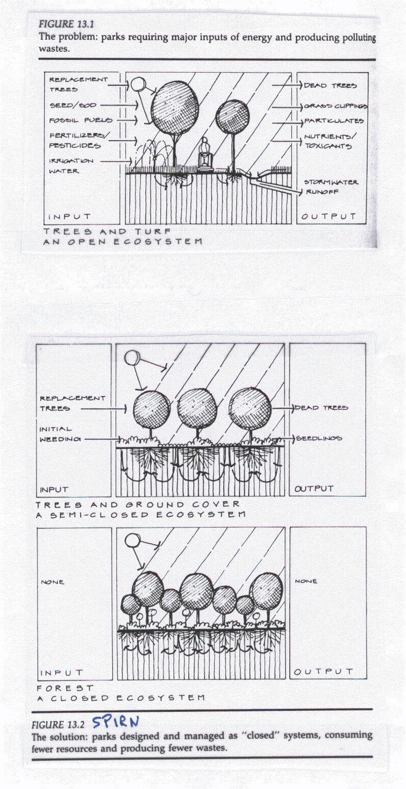
Others are replaced. Others are introduced LINK to Spirn-UrbanVegChanges and Spirn-UrbanHabitatTypes.
Adaptations
can be over short time periods, or via the random selection of traits that
allow some individuals to survive and reproduce more effectively than others.
Imagine
Now
consider the birds of
Habitat…
Buildings… edges; stretches of terrain or edges of terrain; corridors;
Niche…
Generalists tend to survive better than creatures with narrow niche… unless
that niche is a human-supported niche.
Introduced
and invasive species… starlings…
9.
The human footprint … lots
of imprints across
IMAGE: Link to Western US: of USGS
LINK
to GLOBAL… to
FINAL SECTION OF THIS
CHAPTER… So What?
How
BIOSPHERE matters to the physical and human geographies of
Perhaps
what is most telling about the biosphere and
LIST
of “The 15 Words”
Loc
Place
Migra
Inter
Region
Bio
Anthro
Econ
Demog
PoliSci
Sociol
QLife
SELF QUIZ
By
the end of this chapter… you should:
· Be able to explain how
· Understand that abiotic
components of the biosphere relate to subsystems of Earth systems, namely the
geosphere, hydrosphere, and biosphere.
· Be able to explain the
logic behind the EPA ecoregions map.
· Given the EPA ecoregions
map, and with access to the web, be able to assess locations in
· Given the EPA ecoregions
maps and maps that show terrain and temperature ranges, be able to explain why
area’s ecosystems differ, for example, why do the ecosystems of St George
(Washington County) differ from those of Rich County? This is a reasonable
question for a midterm exam.
SUMMARY:
Utah’s
LOCATION, mid-latitude, inland from oceans, and GEOSPHERE with varied
topography and substrate sets broad parameters for the abiotic setting of
ecosystems. As with ecoregions across the globe, plant communities depend on
solar energy, water and nutrients from the atmosphere and soils. Animals
consume plants and other animals. Organisms in Utah have survival strategies to
cope with abiotic and biotic challenges of their ecosystem. Ecoregions are a
way to classify regions based on the biosphere. Utah has portions of seven of
the nation’s XXXX ecoregions. These regions are useful to professionals such as
land managers and planners interested, for example, in fire hazards. But
bioregions are challenging to remember. They have systematic but diverse
characteristics. It would be an unreasonable exam question to draw them from
memory, because they are more numerous, less continuous, and more scattered
spatially than Utah’s regions based on the geosphere, hydrosphere, and
atmosphere. However, it would be reasonable to ask for an explanation of the
characteristics of a given ecoregion or, given a map of Utah’s ecoregions and a
map of Utah’s counties, to explain a given county’s general biological
characteristics.