LEARNING MODULE 02 – GEOGRAPHY of
Location, Location, Location.
LM02-CC00 – Overview - LOCATION and Geography of
By the end of this Learning
Module, you should:
·
Understand why
“LOCATION” is one of the five major themes of geography.
·
Understand ways
we use to LOCATE ourselves, and the state of
·
Understand where
Utah is… with respect to the equator, with respect to oceans, with respect to political
boundaries… and why these matter to Geography of Utah.
·
You also should
understand the Atlas of a Utah School Project and why it is The Learning Tool
of GEOG3600: Geography of Utah.
MAJOR CONCEPT:
LOCATION is one of the “five
themes of geography” because LOCATION influences (some might say is one of the
five controls of) the web of relationships among peoples, places, and the
environment.
LINKS (LM = learning module;
CC = content chunk)
|
LM |
CC |
First, perhaps foremost,
theme of geography: LOCATION. Where is ? |
Lecture Notes |
LINKS to lecture chunks |
MP3 - only |
|
02 |
01 |
Overview – LOCATION |
Not active |
||
|
02 |
01 |
Locate |
|
||
|
02 |
02 |
With respect to the equator |
|
||
|
02 |
03 |
“ to physical geog |
|
||
|
02 |
04 |
“ human geog political
boundaries
|
|
||
|
02 |
05 |
Location of |
|
||
|
02 |
06 |
Atlases |
|
||
|
02 |
07 |
Atlas for a |
|
||
|
02 |
08 |
Atlas walkthrough example
-UofU
|
LINK
|
|
|
|
02 |
08 a,b, c,d.
|
b make bucket for your portfolio c create pages of your atlas d send pages to Cohort Group |
|
||
|
|
|
Self Quizzes-none for this module
|
|
|
|
LM02-CC01 –LOCATION… one of the “Five Themes of
Geography” –
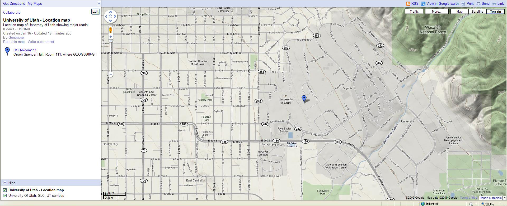
SEQUENCE... Where am I... in universe, in Milky Way galaxy, along one of its shorter arms, in solar system, on Earth, on North American continent, in the conterminous United States of America, in the western US, in Utah, in Salt Lake County, in Salt Lake City, on the East Bench or University area of Salt Lake Valley, on the University of Utah campus, in Orson Spencer Hall, in room 111 (some of you will be elsewhere ... but you could do this fly - in.)
Note how we changed scale... and how your knowledge of context changed, the diverse ways maps indicate location, and how you located Utah.. Maps are models ... an abstraction of the "real" world.
Thought questions:
Where am I? Where is? You are
here…? – and the reply is LOCATION
Why is “Location” one of the
“Five Themes of Geography”… and probably not in the top five themes of
economics, or geology, or genealogy… although essential to each of these?
Why do real estate agents say
the three essential characteristics of a home for sale is: location, location,
location?
What is location? And how
does it differ from “place”…
What other words are related
to it?
What are
the other of the Five Themes of Geography?
What does “LOCATION” tell us?
Geographers think everyone
considers the question … Where Am I?
We’ll talk about Wallace
Stegner’s admonition… “If you don’t know where you are, you don’t know who you are.”
We’ll talk about a “sense of
place” often and for most of LM03.
What is special about
geography… it is spatial!
Location is relative to
something … or to a set of coordinates.
Word use… location… locus…
Maps are to geographers as
scissors are to a hair stylist, scores are to an orchestra, briefs
are to an attorney.
Maps are “models” … models of
LOCATION. Maps (including digital maps such as GIS models) are the geographers
medium of communication.
Collections of maps are
Atlases.... usually with a purpose: reference maps and thematic maps. .
Caution: “All maps are flat…
therefore all maps lie!”
What is scale? Does a
“small-scale” map fit on a small piece of paper? (yes).
LM02CC02 – Locate
How?
Location means referencing to
space.
Location is with respect to something, such as:
Left and right are directions
with reference to you.
Or the world with respect to you. LINK Greer - Atlas of UT
Or... Location can be to an "arbitrary" spot.
Initial surveys in
Resulting in an agreed-upon grid LINK to township range, LINK salt lake meridian.
Eventually, survey control
was carried into
Or... Location can be with respect to a known object or place or street LINK to 1:100,000 USGS topo , LINK to 1:24,000 scale topo
Or... Location can be with respect to an geographic grid
Earth as blue marble, no boundaries, no grid Nasa LINK
Earth with "Geographic Grid" LINK
“latitude… flatitiude"... more on this later
Or... Location can be with respect to an array of satellites (GPS) LINK;
GPS is with respect to
satellites.
So what?
What is “scale”?
Does a small scale map of
If you are interested in cartography, this is a terrific handbook on geographic coordinates and projections; LINK
LM02CC03 –
Why the equator… what does
equator mean?
How does location vis a vis the equator work?
What are latitude and
longitude and why measured in degrees?
Where is
How is this figured out?
Why does it matter?
Which is more important to
human geography… latitude or longitude?
Where is
How is this figured out?
Why does it matter?
Geographic Coordinates – how
big is
We’re closer to the Equator
than to the North Pole.
So what? LINK
Location with
respect to the equator controls seasonality, controls the balance between night
and day, and therefore greatly influences
How much sunlight reaches the ground... St. George, Utah's Dixie... DRM family in Rich County
Unlike latitude… longitude is
arbitrary… zero degrees could have been agreed upon … anywhere. The Brits
earned it!
As realtors say: what matters
most… location, location, location.
LM02CC04 – So What... Utah's location with respect to features of physical
geography …
Physical Geography = Earth
systems (can you name the 5 subsystems of Earth systems? (GHABA))
Geo / Hydro: Where is
Why does it matter?
Temperature ranges... how far from oceans... how far from equator LINK
Human Geography =
perspectives of social and behavioral sciences... review... what are the seven perspectives of social and behavioral science we refer to in this course
Where is
Why does it matter? (Anthro; Econ; FamConsum; Geog; PoliSci; Psych; Soc?)
THEMES of Geography... interactions... migration... closer = more so (Toblers Law)
LM02CC05 – Location of
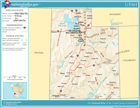
Earth at night... Utah and environs from Dark Sky website; ; borders of US from Dark Sky; "negative" of Utah and environs (Dark Sky); How do you locate Las Vegas... and St George. How about Grand Junction? The Wasatch front is pretty easy... how about Great Salt Lake. . (there are some trickster bright spots on the map, meaning... don't assume all bright places are communities... any idea what those bright spots are in northwestern Utah... what communities? -- if we were in Africa or South America... similar points of light might be agricultural burnings... what would flare in southwestern Wyoming and northeastern Utah?)
Show Utah boundaries LINK - Dark Sky
Are the patterns patterns random? What controls them?
Why is
What controls the location of
GEOGRAPHY IS… Reminder
And the course objectives of
GEOG3600… this course are… LINK
LM02CC06 – Atlases
What is an atlas?
Why are there atlases?
What are some different
atlases?
Is Google Earth an atlas?
Is Google Maps an atlas?
What makes a good atlas?
Examples of a few of my favorite Atlases
We could start with maps... reference maps such as the State of Utah's official highway map... or a thematic map (map with a theme) such as the State Geologic Map of Utah
I'll talk about a few:
Benchmark Atlas for Utah is a reference atlas LINK
The Atlas of Utah is a thematic atlas... it's theme is Utah. Too bad it is out of print and out of date. It still is very useful. LINK LINK.
Brown et al - Historical Atlas of Mormonism LINK cover; LINK inside
Gaustad Barlow is an atlas with broader context- LINKcover. LINK inside
. . .
Some are fat, some are thin LINK
All atlases have maps and have text.
This book on place names is not an Atlas although it is all about places LINK LINK
Zick and Smith is not an Atlas. It's your text for the third of the three parts of the course. In the mean time you create an Atlas from what you learn from Learning Module .
LM02CC07 – Atlas for a
Here is a mantra about
empowerment … learned while at Utah Geological Survey.
How do we empower people to
prepare for Earthquakes in
·
Before people are
empowered to take action…
·
Must hear the
message…
·
Must understand
the message…
·
Must personalize
the message…
·
And then they are
empowered to take action.
The Atlas for a Utah School
Project happens to be a genuine service project – however – that is NOT its
main objective. The main objective of the Atlas for a Utah School Project is to
“personalize” concepts of the course. I’ll discuss, for example,
Your atlas, like all the atlas examples, will have a defined format. Your atlas format is: Chapters that follow the Learning Modules made up of pages you create. Your pages have an image (a map, or graph, or photo) and text that explains what the image shows and why it matters. Your homework assignment HW04 creates the three pages of Chapter 1 of your Atlas.
The Plan…
·
Every student in
GEOG3600 chooses a school from the list of schools in
Sites with info on
State Office of Education directory:
·
Every student
will be in a Cohort Group that will share tips and ideas and feedback about
Atlas chapters.
·
Advice: choose
your school base in part on –
o
Geographic
diversity for your Cohort Group. You will learn more if you have diverse locations of schools.
o
Your interests
(where you went to school, where you might like to live, a place you’ve never
heard of, a place you love, a place someone you know if familiar with, a place
you might visit)
Week after week you’ll create
pages for chapters for your Atlas. I’ll give you a template, meaning an
outline; often I will give you a few figures that I expect you to use;
sometimes I give you text to include. For example: for Chapter 01 – Location …
you’ll create at least three pages. I’ll give you all the text and all the
figures for the pages. Of course, if you want to create
other pages… go for it.
The pages are your pages, not
your Cohort Group’s. Your cohort can suggest approach, where to find images.
They will review your work and you will review theirs. You’ll learn concepts of
geography and skills of a geographer. The Atlas is a genuine service learning
project and it goes to the school principal who generally forwards it to a teacher. However the service learning part
is incidental to the direct purpose of the project: it is for you… for your
learning. If you can translate concepts from learning modules to your school’s
location; if you can train yourself to (a) observe and (b) to analyze what you
see for that location and in the context of your Cohort Group schools… you’ll
know
LM02CC08 – Atlas for a Utah School Project – walk through
process for - UofU
Let me walk you through your HW04-Assignment – Chapter One – LOCATION
Here's the link to step by step instructions HOW TO CREATE POST PAGES.HTM .
By Spring Break, you will have a heart beat sense of physical geography of "your" school, as the clothes sales people say... "I guarantee it".....