Earth Science Outside
TECTONICS RULES!!
Session 2 – April 2, 2018 – UofU Osher – Earth Science Outside. DRAFT for some details but logistics are solid.
Meet at Faultline Park’s picnic tables.
Address: 1041 East 400 South, 84102.
NOTE: There’s generally parking available along 400 South between 9th and 10th East and along 10th East between 4th and 3rd South. The park is an easy walk from the TRAX station at UofU Stadium Parking.
Some logistics:
NOTE: For the lecture, we’ll sit at the picnic tables and extra lawn chairs will be provided.
NOTE: The mapping exercise takes about a half hour. We will walk around this block. Participants will use colored pencils (provided) and a blank map (provided) and be citizen scientists, mapping this expression of the Wasatch Fault.
NOTE: Safety first. ALL outdoor exercises have inherent safety concerns. Be prepared with sensible shoes, walking stick if desired, clothing appropriate for weather, etc. SAFETY is a group endeavor. Speak up for safety! There’s never been an issue at this site, let’s keep it that way.
Map showing location of Faultline Park.
Click HERE for link to Google Maps.
Here’s the topo map (1:24,000 scale topographic map, a portion of the USGS hard copy topographic map.
Alternate Site if bad weather
No alternate site will be posted until we know for sure bad weather. Check back the Saturday before class.
Anticipated Schedule and Activities:
1:30 PM — Welcome and Step One of Landscape Literacy… Breathe! and Be mindful of patterns.

BasinAndRangeFromSLCounty-AWolcott-2018-BasinsAndRanges of Basin and Range.
- Salt Lake Valley is a basin of the Basin and Range. Utah Valley and Tooele Valey and the broad, flat-bottomed valleys west of the Wasatch fault from Utah through Nevada are basins of the Basin and Range province.
- The Wasatch fault zone is the boundary between the Basin and Range region to the west and Rocky Mountain region to the east. The Wasatch Range is a mountain range within the Rocky Mountain province.
- Regions look different because they are different: they have had different geologic histories.
Repeat to remember, Remember to repeat: Five steps toward the JOY of landscape literacy. Today we focus on Steps One and Two.
- Step one: look around. Be mindful of patterns. Breathe deeply.
- Step two: Look deliberately at patterns of shapes of landforms. PATTERNS… Handout (below) … What is there to notice? Deliberate awareness of landform shapes and consequences.
- Step three: Look deliberately at patterns of materials, specifically sediment versus bedrock.
- Step four: Focus on patterns in bedrock. Be mindful of layering and patterns such as tilting or folding. Be mindful of crosscutting relationships, what cuts what, for example, does a stream channel cut the bedrock?
- Think about what you see.
Practice looking locally (within a 1000 ft), and then mid-field (a couple miles away), and then far field (several miles away). What do we notice about repeated patterns, or patterns that don’t repeat.
2:00 PM — Lecture: Tectonics Rules!
Dance of the Plates (note: content and links are below).
Reenactment of the evolution of the Basin and Range region (Genevieve’s blocks).
2:30 PM — Participants as Earth scientists. Map the fault that cuts this city block… with supervision.
NOTE: Colored pencils and handout provided. Enjoy being a citizen scientist. Page two of handout (see below).
By the end of Session 2:
Participants should be confident about Step 1 of Landscape Literacy: PATTERNS. Mindful moments.
Participants should be able to practice Step 2: Deliberate awareness of PATTERNS of shapes of landforms and interconnections to the five subsystems of Earth systems (geosphere, hydrospere, atmosphere, biosphere, and anthrosphere).
Participants should appreciate the importance of tectonics to Utah’s landscapes. Tectonic forces largely set the stage for regions by changing what is high and what is low. Then agents of erosion / deposition modify the scene.
Review terms and concepts:
What are landforms?
What are physiographic provinces?
Why do physiographic provinces differ from each other?
Tectonics rules!!
Evidence of Geologic History of Utah — Specifically to Chapter 9 – Now! Stretching west.
This course asks participants to appreciate how Earth scientists have pieced together the geologic history of Salt Lake County as nine chapters. We live in Chapter 9: Now! Stretching to the West. This chapter, based on tectonics, began about 22 million year when tectonics shifted from dominated by isostatic adjustments (sorry for jargon) and igneous activity to active stretching westward (extensional tectonics). Chapter 9 Now! Stretching west is … now… and continues through the present and beyond.
What evidence do you see?
What evidence do you witness of the most recent “superposition” of sediments? What do they lie across?
What evidence do you witness of cross-cutting relationships? What rock units (bedrock units) are cut by the Wasatch fault zone?
Interpretation:
Chapter breaks are based on tectonics. If you knew the OLDEST units that were faulted by extensional tectonics, wouldn’t you know the beginning of the pulling apart of the Basin and Range? Based on evidence of western Utah, extension began about 22 million years ago. By about 5 million years ago, we would recognize the major mountain chains and valleys of our Basin and Range. There is no evidence of how long this chapter will last.
The Wasatch fault is a Chapter 9: Now! Stretching to the West feature. It lies along the Wasatch Line a zone where Earth has accommodated change for half a billion years. The Wasatch Fault zone is due to tectonic extension.
Consider Mount Olympus. The bedrock of Mount Olympus happens to be from Chapter 2 – Metamorphism Lite and Chapter 3 – Shallow Seas. Don’t confuse the age of bedrock of a feature with the age of a feature. Faulting along the Wasatch Fault drops the valley down and is what makes the landform (Mount Olympus). Mount Olmpus, the landform, therefore is a Chapter 9 feature! Same with Antelope Island. Same with the Oquirrh Mountains.
How about here at Faultline Park. As we walk around the block and witness patterns of topography, and vegetation, and urban development… decide in your mind whether the fault we are mapping cuts sediments, specifically, does it cut sediments of Lake Bonneville of about 15,000 years ago (not long ago… basically the present). What do you wonder about that?!
From our Session 1: “Landforms are generally young compared to the bedrock they are made of. Antelope Island and Stansbury Island are both Chapter 9 – Now Stretching West landforms. Antelope Island’s bedrock is very old (Chapter 1 – Metamorphic Basement) and Stansbury Island’s bedrock is Chapter 3 – Shallow Seas. But the islands are young features. The islands are ranges of the Basin and Range surrounded by low places due to extensional tectonics of Chapter 9 – Now Stretching to the West.
Keep thinking: shape, materials, process. Think: clues to Utah’s geologic past and… History of Planet Earth.
CONTENT
Repeat to remember, Remember to repeat.
Embrace the JOY of landscape literacy. The five steps to landscape literacy:
- Step one: look around. Be mindful of patterns. Breathe deeply.
- Step two: Look deliberately at shapes of landforms.
- Step three: Look deliberately at patterns of sediment versus bedrock.
- Step four: Focus on patterns in bedrock. Is there evidence of layering? What about crosscutting relationships or folding, or tilting of layers?
- Think about what you see.
Content: Tectonics Rules!!
Click HERE for USGS map This Dynamic Planet . Map from This Dynamic Planet USGS website

Click HERE for USGS pamphlet explanation (excellent) This Dynamic Earth. One map from that pamphlet:

Content: Physiographic provinces are drawn based on patterns of LANDFORMS, the cumulative effects of Earth science processes.
Utah’s three major physiographic provinces (the Basin and Range, Colorado Plateau, and Rocky Mountain physiographic provinces) have had different geologic histories, much as the Andes mountain and Amazon lowlands are experiencing different geologic histories today.
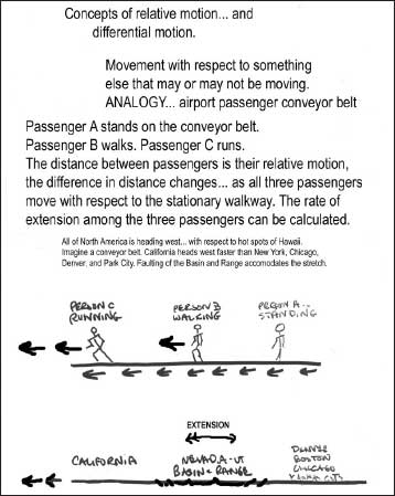
Today (meaning Chapter 9 – Now, Stretching to the west), the Basin and Range physiographic province is being pulled apart due to extensional tectonics (!) while the Rocky Mountain and Colorado Plateau regions are tectonically stable in comparison. GPS units measure movements, for example, a place on Antelope Island is moving west faster than those of the Uinta Basin.


The arrows show direction of movement of GPS stations and their relative speed. Note the patterns of the arrows west versus east of the Wasatch fault.
Content: Earth is not getting noticeably bigger or smaller. If Earth’s surface is getting shorter in some regions, it will be getting wider in others (extensional tectonics).
Imagine the geometry of a set of three blocks. When the two end blocks are pulled apart, the central block drops.
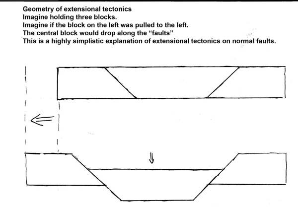
Content: Next step… think of the basins and ranges of the Basin and Range as a series of wooden blocks


Content: Geologic History of Utah Chapter 9 = Now! Stretching to the west.
About twenty million years ago, none of the features that make up the surface of Salt Lake County had been formed. Their bedrock was there, having been formed in previous chapters but the landforms that we see today, such as the ranges and basins of the Basin and Range were not there yet. The LANDFORMS, such as Antelope Island and Stansbury Island, (careful… that’s the SHAPES on the surface of the land) are rarely the same age as the BEDROCK they are made of. Tectonics Rules!! Extensional tectonics of what we are calling “Chapter 9 – Now! Stretching west” created the Basin and Range including the Salt Lake Valley and the Wasatch Front.

Content: Physiographic regions are based on patterns of landforms.
Think about what you know of differences of patterns of landforms of the Basin and Range and, for example, the Colorado Plateau region.
Tectonics rules! The active tectonics today differs for the Basin and Range versus the Colorado Plateau.
A challenge question: how does the contrast of active tectonics affect the citizens sense of hazards?
Content — some terms
Fault
Earthquake
Tectonics
Extensional tectonics
Compressional tectonics
Handout – 2 pages –
Page 1. Practice deliberate recognition of patterns of landforms.

Page Two: Map the fault that cuts through the city block of Faultline Park.
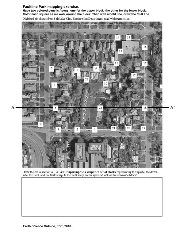
Handout pdf = ESE-FaultlineParkHandout-p01-02
By the end of Session 2:
Participants should have a heart-beat understanding that extensional tectonics results in down-dropping of “blocks” of western Utah’s crust resulting in the Salt Lake Valley, the Oquirrh Mountains, and the Wasatch Range.
Participants should be able to explain to each other why the age of most LANDFORMS they know and love is younger than what the LANDFORM is made of: Mount Olympus, Farnsworth Peak, Ensign Peak, and… The Wave, Zion’s White Throne, … .
Next session, Session 3 – Patterns of Bedrock at the mouth of Parleys Canyon.
Remember to check HERE for links to the latest information on all sessions of the course.
Observation: Step 3 of the Joy of Landscape Literacy, meaning, we’ll examine patterns of bedrock.
Content: Using the simple concepts of superposition, cross-cutting relationships, and original horizontality… you too can figure out age relationships of bedrock units at Parleys Canyon. JOY!
No homework. Just breathe! and be mindful of the Earth science that surrounds you.