Earth Science Outside
INTRODUCTION to LANDSCAPE LITERACY
Session 1 – March 26, 2018, UofU Osher – Earth Science Outside–
Meet at Fort Douglas “Commander’s House” (Osher’s headquarters)
Address: 1965 de Trobriand St, SLC, UT 84113
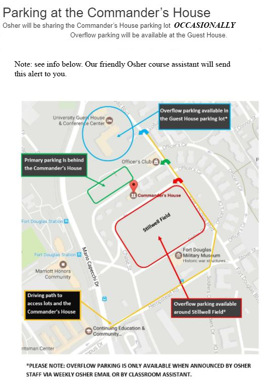
NOTE: Visit the Osher website for further information about parking, and directions to the Commander’s House. https://continue.utah.edu/maps/commanders-house
Some Logistics.
NOTE: For the initial lecture, we’ll meet at Osher Headquarters at the Commander’s House in a classroom, To Be Announced. Toward the end of the session we’ll go outside for views of Salt Lake County’s landscapes. Let’s hope for good weather.
NOTE: Safety first. ALL outdoor exercises have inherent safety concerns. Be prepared with sensible shoes, walking stick if desired, clothing appropriate for weather, etc. SAFETY is a group endeavor. Speak up for safety! There’s never been an issue at this site, let’s keep it that way.
MAP showing location of the Commander’s House:
https://map.utah.edu/?buildingnumber=620
Parking should be Okay, except sometimes… see attached:
Alternate Site if bad weather –
No alternate site !
Anticipated Schedule and Activities:
1:30PM –Welcome and Course Logistics.
We’ll meet inside, The Commander’s House, The Parlor.
Waiver: Earth Science Outside is… outside! Consider risks before signing the waiver.
Course website: www.earthscienceeeducation.org Return here for updated information.
2:00PM–Lecture: Course Overview.
Five steps toward the JOY of landscape literacy. Today we’ll introduce the five steps and practice Step one.
- Step one: look around. Be mindful of patterns. Breathe deeply.
- Step two: Look deliberately at patterns of shapes of landforms.
- Step three: Look deliberately at patterns of materials, specifically sediment versus bedrock.
- Step four: Focus on patterns in bedrock. Be mindful of layering and patterns such as tilting or folding. Be mindful of crosscutting relationships, what cuts what, for example, does a stream channel cut the bedrock?
- Think about what you see.
2:30PM–Walk about on Fort Douglas Parade Ground.
Most important, let’s go outside and practice Step one of the JOY of landscape Literacy:
- Step one: look around. Be mindful of patterns. Breathe deeply.
PATTERNS … and landscape literacy.

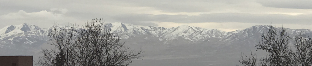
From UofU Eccles Bridge, looking west toward Farnsworth Peak of the Oquirrh Mountains.

From UofU Eccles Bridge, looking south toward Mount Olympus and the Wasatch Mountains.
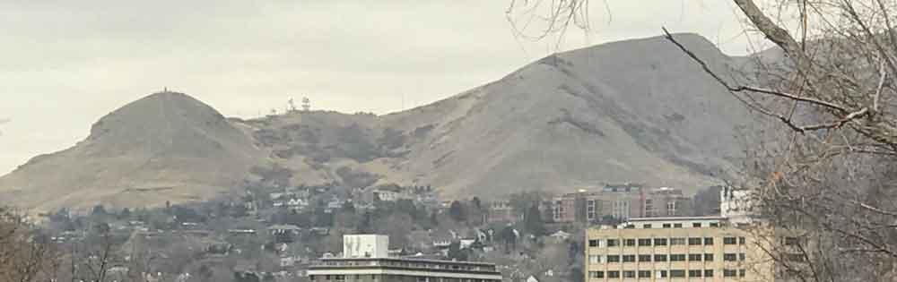
From Fort Douglas east of the Eccles Bridge, looking north, Ensign Peak.
CONTENT
We’ll cover much of this content about two big topics before we head outside to appreciate patterns.
- Relative age – the “rules” for figuring out younger than / older than relationships.
- Salt Lake County’s geologic past – Four minutes to summarize four billion years.
Content A:
Relative age – the “rules” for figuring out younger than / older than relationships. Earth scientists use a few rules to figure out younger than / older than relationships.
-
- Superposition: If a rock layer is laid across another, the one on top is younger.
-
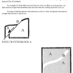
- If one geologic feature cuts another, the one that is cut is older. You have to have a cake before a slice of cake.
-
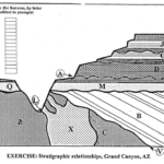
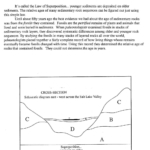
- Schematic of the geologic units and surfaces (circled) of the Grand Canyon. (ESE, 2000).
- Superposition: if one rock unit has been laid on top of another, the one below had to be there first and is older than the one across it.
- Crosscutting relationships: to have a slice of cake, the cake has to be there first.
- Tilting: if layers start out relatively horizontal and now are tilted or folded, the tilting and folding happened after.
- Fossils.
Content B:
Salt Lake County’s geologic past – Four minutes to summarize four billion years. Based on those general rules plus abundant additional evidence, hundreds of Earth scientists have mapped Utah’s geology and figured out a great deal about Utah’s past.
This Osher course will use the approach of nine chapters based on tectonic phases of Utah’s geologic past, according to L.F.Hintze and as taught by G. Atwood.
From youngest to oldest:
Chapter 9: Now stretching west.

Chapter 8: Impressive igneous.

Chapter 7: Seven UP!

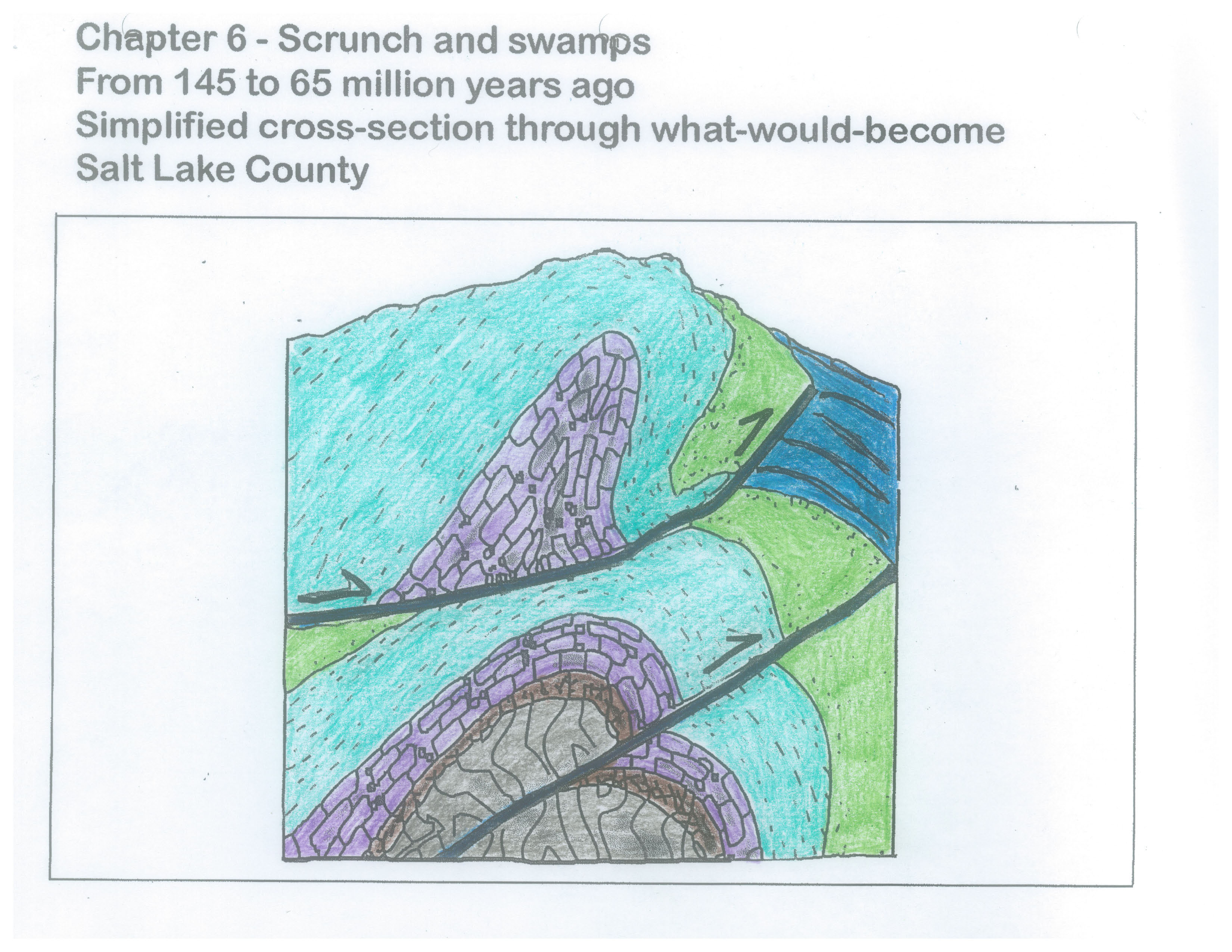
Chapter 6: Scrunch and swamps.
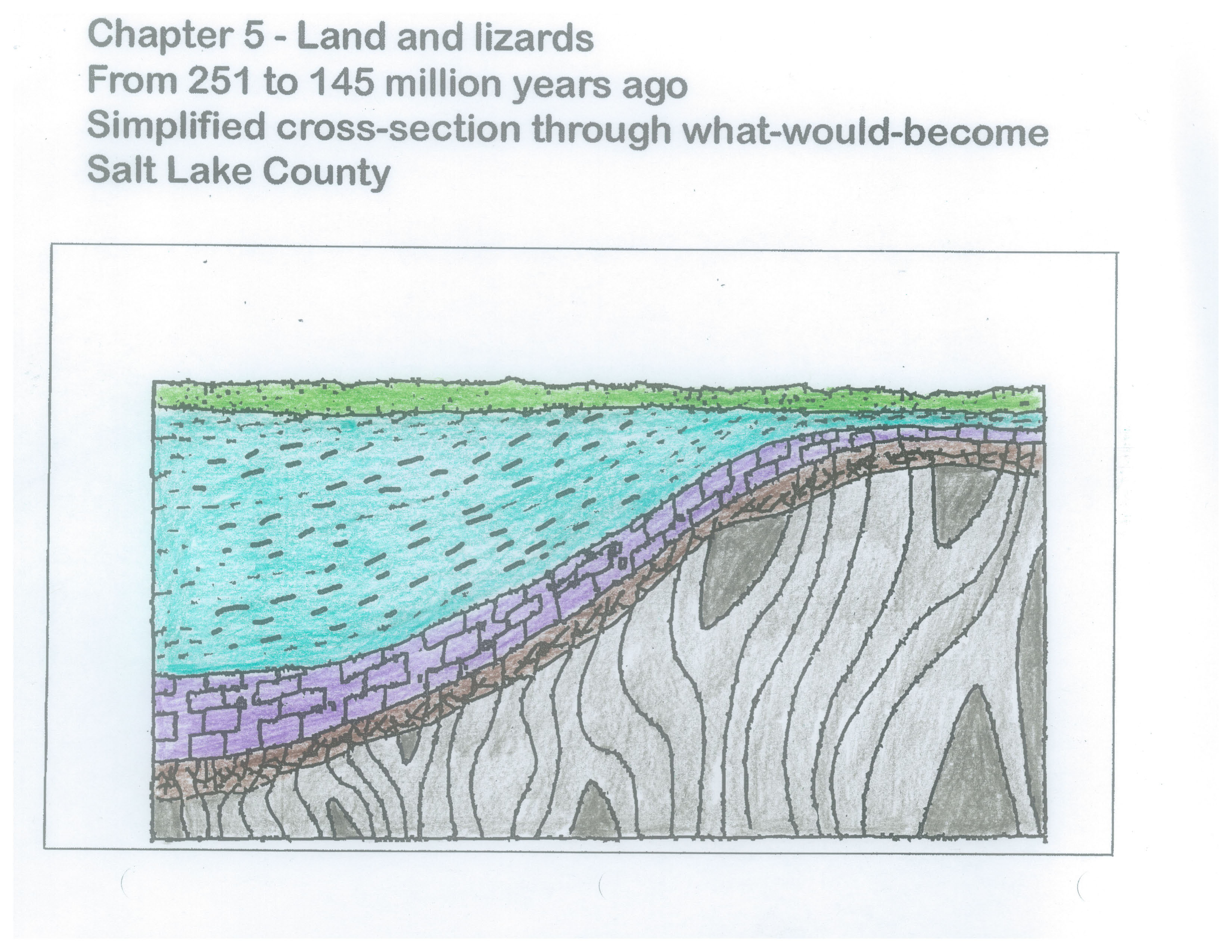
Chapter 5: Deserts and dinosaurs.
Chapter 4: Broad basins.

Chapter 3: Shallow seas.

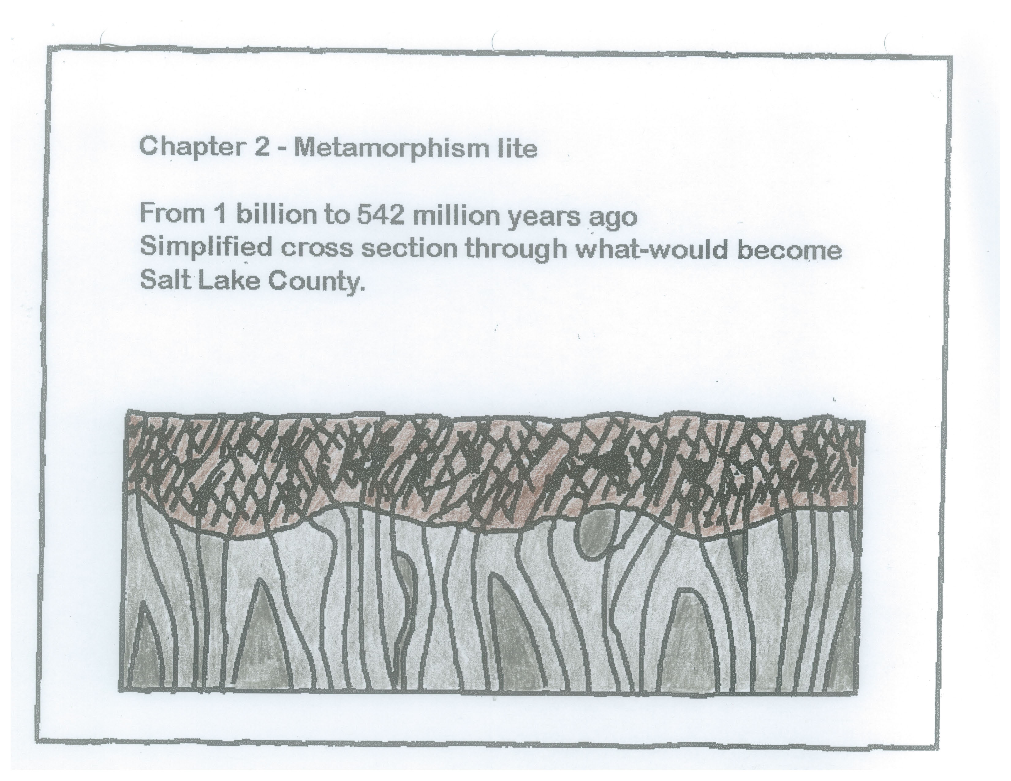
Chapter 2: Metamorphism lite.
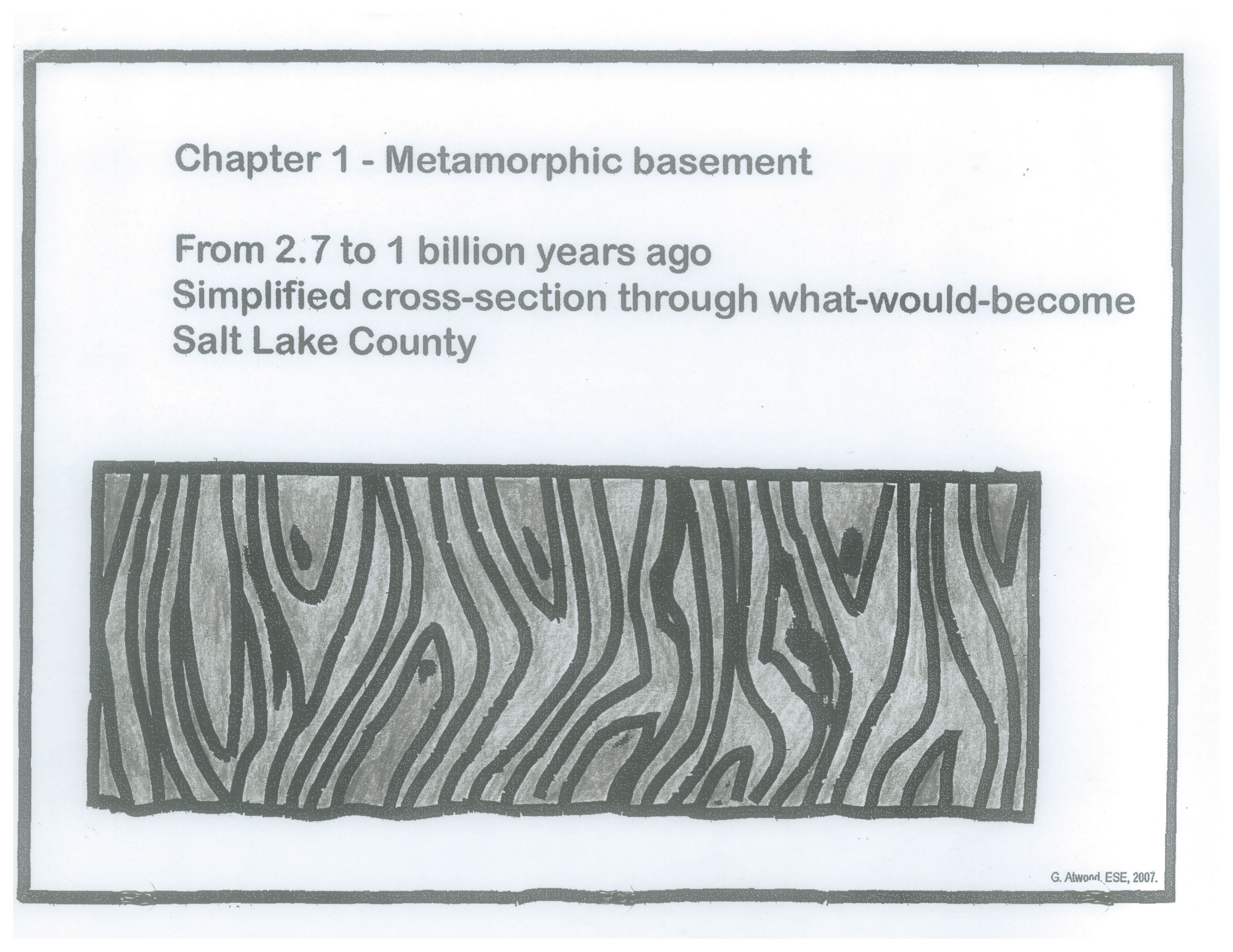
Chapter 1: Metamorphic basement.
Content C:
Patterns and Mindfulness.
According to the National Academy of Sciences, etc, Framework for K-12 Science Education, patterns are the the first of seven crosscutting concepts that real scientists use in real life.
For landscape literacy become mindful of:
- Patterns of landforms: Notice shapes of landforms, naturally occurring physical features on Earth’s surface.
- Patterns of Earth materials: Distinguish bedrock versus sediment.
- Patterns as evidence of process: such as: have rock units been tilted or folded? are some rock units directly on top of others? do some features cut across others?
- ALL landforms (according to G.Atwood) are the product of tectonics and erosion/deposition. Tectonics rules! Water (and other agents of erosion and deposition) then modify the shapes of Earth’s surface.
Content D:
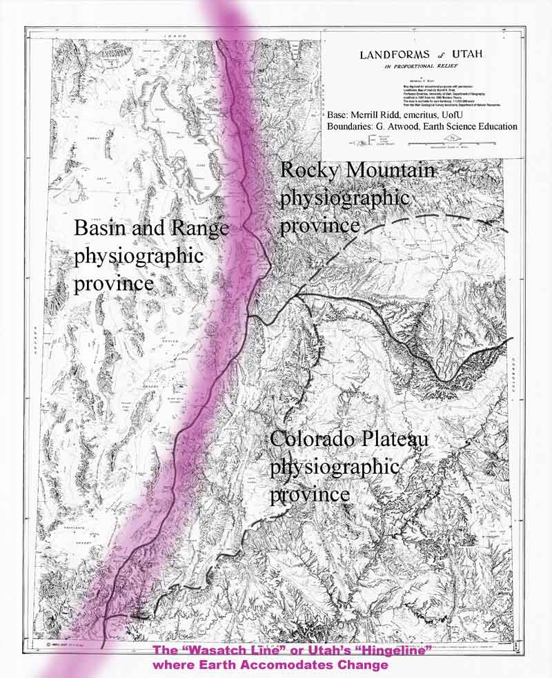
Utah’s Wasatch Line or Hingeline is a region where Earth has accommodated tectonic forces for about half a billion years. (Base, Ridd, 1960. used with permission, modified by Atwood)
The hypothetical “Wasatch Line” runs from the Idaho – Utah border to St George. Today (meaning the most recent few million or so years) it is the general boundary between the Basin and Range physiographic province on the west and the Rocky Mountain physiographic province and the Colorado Plateau physiographic province to the east. It’s the subject of Session 2 of Earth Science Outside. Preview: Earth has accommodated change along this zone for over 600 million years. Big deal. Today, Utah’s crust is extending westward, horizontally via the Wasatch Fault system along this zone and along many additional faults of the Basin and Range region.
Content – some terms:
A physiographic province is a region on Earth’s surface defined by landforms.
Utah has three regions (some say four) with decidedly different patterns of topography. Therefore we have three physiographic regions. ow can that be? Those regions have had different geologic histories much as South America’s Andes Mountains are experiencing a geologic present that differs from that of the adjacent Amazon Basin. Because Utah has three regions with contrasting geologic histories, Utah has three sets of resources, three sets of scenery, and three sets geologic hazards. Aren’t we special!
A landform
is a friendly term for just about any naturally occurring feature on Earth’s surface. But think beyond that. For this course, a landform is a naturally occurring, geologic feature, on Earth’s surface, with characteristic shape (meaning shape that is characteristic to it), characteristic materials (meaning materials characteristic to it), and created by characteristic processes. Note that is my definition, G. Atwood.
Location versus place
Brigham Young on witnessing Salt Lake Valley did not say “This is the location!” Location responds to the question “where is.” Place, according to G. Atwood is “location with and attitude.” It has an emotional connection beyond location. Also, distinguish between sense of direction and sense of place.
Landmarks
Landmarks can be physical or cultural features that act as ___. Today, examine the contrasting patterns of the Oquirrh Mountains versus the Wasatch Range, and contrasting patterns of Mount Van Cott versus Red Butte. We’ll revisit several physical landmarks during this course. Today, in your mind’s eye, review contrasts among:
Farnsworth Peak of the Oquirrh Mountains.
Bingham Copper Mine and waste rock.
The Traverse Range (peg… mountains or range)
Lone Peak of the Wasatch Range
Mount Olympus (check spelling Mt or Mount) of the Wasatch Range
Ensign Peak of the Salt Lake Salient (of the Wasatch Range)
and Great Salt Lake with Antelope Island and Stansbury Island.
Don’t hesitate to add another to our list. What is your favorite landmark and why?
HANDOUT
Will be handed out (!) y180326-OsherHandoutSession01-ForWebReduced
By the end of Session 1:
Participants should appreciate how they can see patterns, should appreciate how their own observations matter, and appreciate what is meant by mindfulness of observation.
Participants will try to embrace uncertainty as a way of understanding and as a part of the JOY of landscape literacy.
Participants will recognize that they already appreciate contrasts of the topographic features west of the Wasatch Range, the Basin and Range region of Utah, versus eastward, the Rocky Mountain and Colorado Plateau regions of Utah. Participants will wonder how that came to be.
Next session, Session 2:
Remember to check HERE for links to the latest information on all sessions of the course.
Observation: Step two of the Joy of Landscape Literacy, meaning, we’ll examine patterns of shapes of landforms.
Content: Tectonics Rules! As a sweeping generalization, tectonics sets the stage of what regions are higher and which are lower.
No homework. Just breathe! and be mindful of the Earth science that surrounds you.