WebText-
GEOGRAPHY OF
Chapter 10 –
DRAFT
webtext by G. Atwood, 2012
Use
with professional courtesy and attribution including attribution of original
sources where indicated.
LINK
to printable version… it may differ a bit from this web-posted version.
Subtitle:
the
human footprint… footprints just about everywhere
BIG CONCEPTS: (reminder: Geography of
Utah can be explored via themes of geography – Part 1 of this web-text, and via
each of the subsystems of Earth systems – Part II of this web-text. The five
subsystems of Earth systems are: geosphere, hydrosphere, atmosphere, biosphere,
and anthrosphere. This chapter explores
1. The ANTHROSPHERE is the
fifth of the five subsystems of Earth systems; we’ve earned it, right or wrong.
2. Human impact, the human
footprint, goes beyond the places we live and work
3. The history of
environmental impacts of the 20th century parallel increases in population and
effects of urbanization.
4. Something new under the
sun… effects of urbanization and life style on Earth.
5. Geographers can summarize
some aspects of
6. Early peoples: we tend to
know more about recent history than more distant times. Peoples have lived in
7. Lifestyles of Early Utahns,
including food, shelter and clothing were affected directly by physical
geography, the subsystems of Earth systems.
8.
9. Example of a failed
community of southwestern
10.
Another
example: Iosepa,
11.
Communities
fail for reasons of geography… physical and human geographies.
12.
Land
ownership reflects interactions among
EVIDENCE. Examine these images in
the context of spatial patterns and impacts of humans ... .
Images
Dark sky negative for Utah and vicinity
UT-CitiesUT- Utah DoT- Highways coarse scale
LandOwnershipUT - Source - SITLA2006
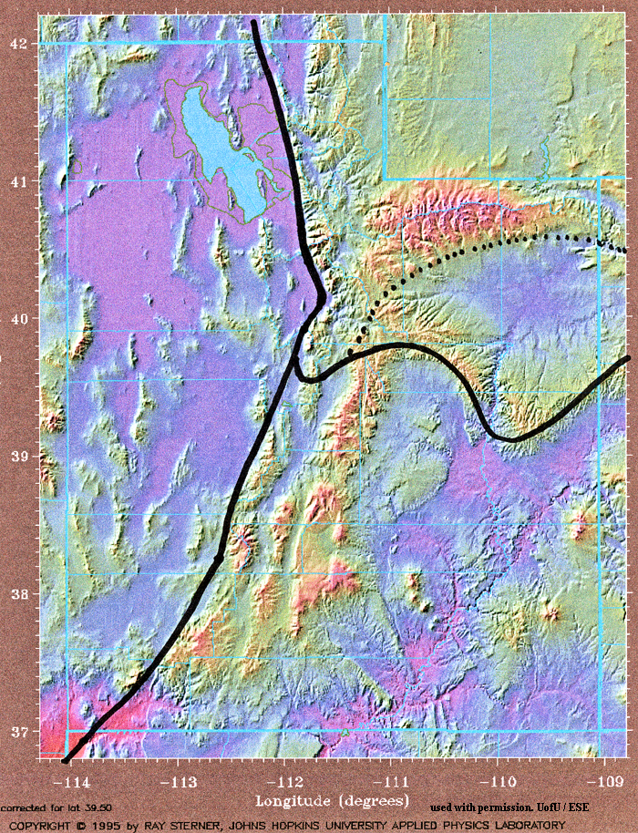
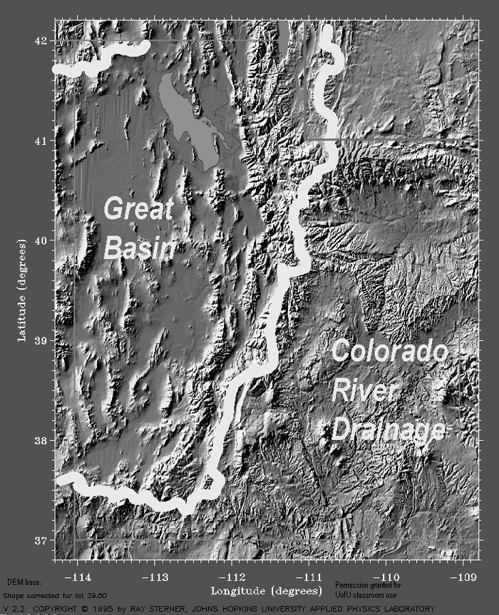
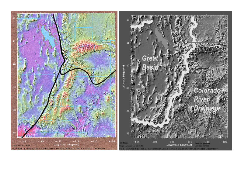
ESE-UtahRegionsOfGeosphere- Sterner Base
ESE-UtahRegionsOfHydrosphere- Sterner Base
ESE-UtahRegionsOfAtmosphere- Sterner Base
ESE-UtahRegionsOfBiosphere-EPA-Level-III... EPA-EcoRegionsLevel-IIII
Quotation:
“Nature to be commanded, must be obeyed” Sir Francis Bacon
LINK
to The 15 Words of GEOG3600 and version that can be printed.
CASES:
One - UofU and Office of Sustainabililty
Two - Who was here before UofU... and before LDS pioneers
Three - Why is the UofU here ...
So many to choose from.
Topics… Questions to Ponder
–
What
differences have humans made to
What
would
When
does “history” begin? for Utah? for China?
Overarching Goal of the
Chapter:
Recognize human impacts through time.
MAJOR CONCEPT:
Humans
have lived in North America at least 13,000 years, from about the desiccation
of
Corollary:
Even into the 19th century,
Specifics: by the end of
this chapter… you should:
· Be able to show on a map,
distribution and overlap of early
· Relate how specific aspects
of physical geography affected the lifestyles of each of these peoples,
specifically: their food, shelter, clothing, and migrations.
· Given maps of terrain,
climate, and ecoregions… be able to hypothesize the reasons why different 19th
– 20th century communities failed.
· Given a map of land
ownership, and maps of terrain and ecoregions… plus some knowledge of
Coaching for students of
UofU GEOG3600-Geography of
The
best preparation for your midterm on Part II: subsystems of Earth systems, and
Terms to understand with
respect to the ANTHROSPHERE
These
terms may be on the mid-term (use your own words) or on quizzes
29
counties of
I-15;
I-80; I-84; I-70
Wasatch
Front
Issues of social
and behavioral science
Anthropology
Economics
Family
and consumer studies
Geography
Geography
of
Psychology
Political
science
Sociology
Atlas
Atlas
for a
Land
ownership
Bureau
of Land Management
Water
rights
State
Engineer
THEORY / CONCEPTS towards
an understanding of PLACE and geography of UTAH
1. The ANTHROSPHERE is the fifth of the five subsystems of Earth
systems; we’ve earned it, right or wrong.
Images:
Bowen: Salt Lake Valley and looking north from TooeleCo (used with permission)
)
The
ANTHROSPHERE is the subsystem of Earth systems impacted by humans. As such, it
includes, but is not limited to the constructed environments of cities and
highways. It includes deforestation, desertification, changed agriculture, and
even changed constituents of the atmosphere.
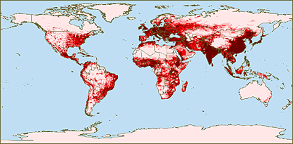
2.
Human impact, the human
footprint, goes beyond the places we live and work.
ADD
IMAGES
USGS,
maps of global and western
The
term “anthrosphere” has been used by Earth systems scientists since the 1980s.
Other, similar terms include the “technosphere” (e.g. McNeil, 2000) that more
narrowly describes effects of technology, and “constructed environment” (xxxx
USGS) that stresses the brick, mortar, and asphalt of human civilizations.
“Anthrosphere” as a word may be evolving. As used in this text, “anthrosphere”
refers to the impacts of humans on the geosphere (such as the Bingham copper
mine); hydrosphere (such as dams and reservoirs including Lake Powell);
atmosphere (from USU cloud seeding efforts over the Uintas to global
concentrations of CO2); and biosphere (impacts of humans from Utah’s early
peoples to the present on the state’s flora and fauna. It includes the
constructed environment, the people of the constructed environment, the impact
of Utahns on
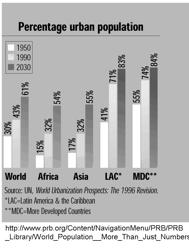
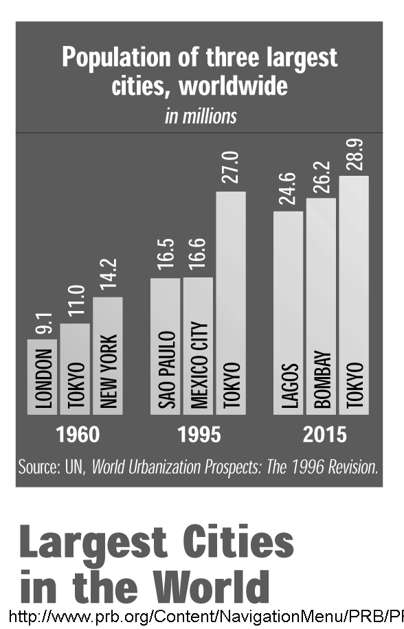
3. The history of environmental impacts of the 20th
century parallel increases in population and effects of urbanization.
IMAGES
Geography matters... proximity 100 km to coasts WRI
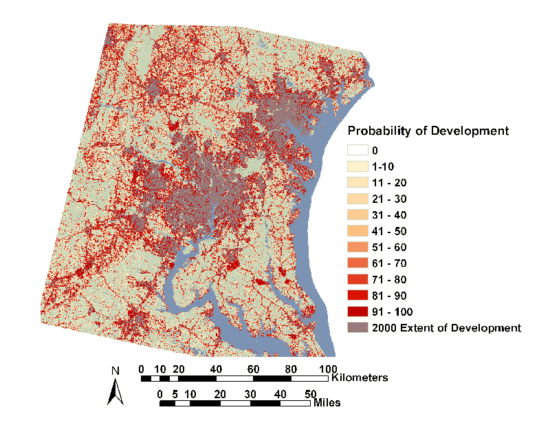
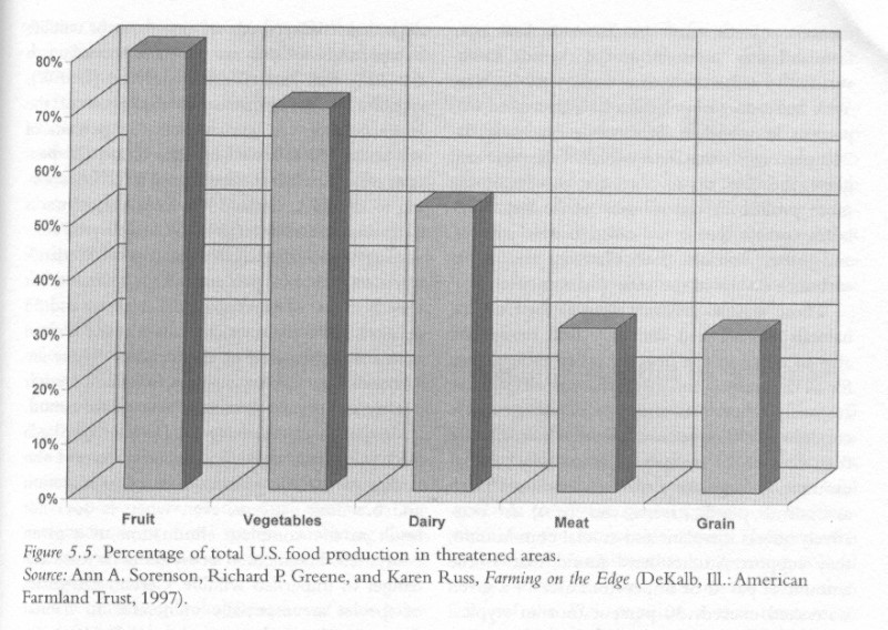
Urban encroachment on agriculture Gillham2002
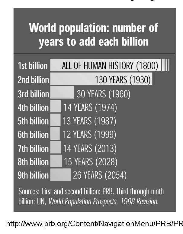
MacKENZIE 8.01 Human Population Growth
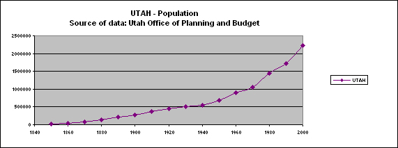
Numbers
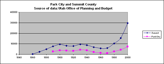
of people have increased globally, nationally, regionally, and in Utah.
National
Demographics
World
population in 2012 exceeds 7 billion and is expected to reach 8 billion in
xxxx. The population of the United States was about xxxx people in 2010, of
whom about xxx live in Utah. Part III of this text explores social and
behavioral science issues and Ch11 specifically explores Utah’s changing
demographics.
Urban
versus Rural
Utah
is urban, by census standards. Approximately xxx of Utah’s populace lives in
rural areas compared to xxxx nationally. However the terms rural and urban do
not capture how the dichotomous nature of urban versus rural has changed.
Although Salt Lake County has a relatively high percentage of lands classified
as XXXX small scale agriculture, Iowa farmers of 1900 or so would hardly
recognize the hobby farms of today as serious rural agricultural lifestyle.
4.
Something new under the
sun… effects of urbanization and life style on Earth.
IMAGES
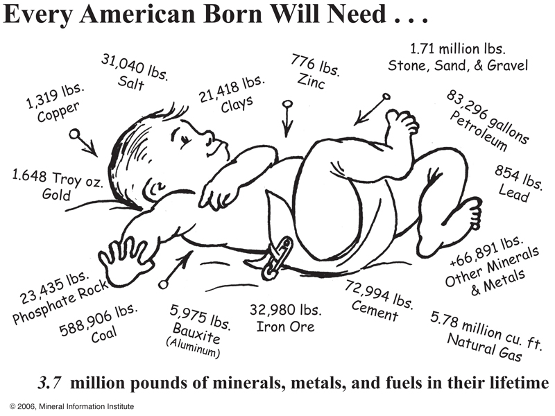
MMI
– what every US baby needs over a lifetime…
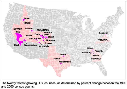
WestFuturesUT fastest growing counties
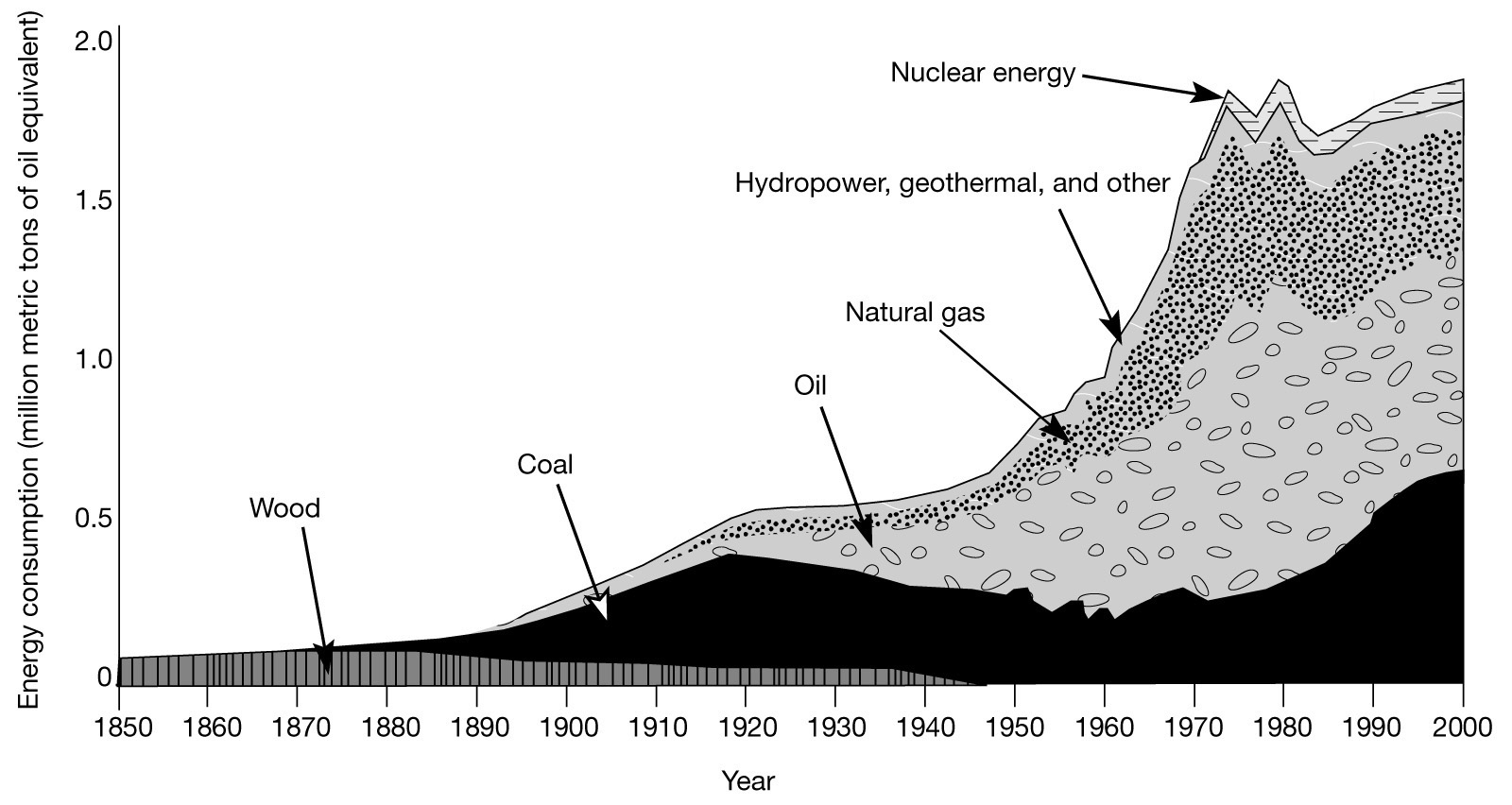
McNeill
in his 2000 book, Something New Under the Sun, history of global impacts of 20th
century urbanization plots changes in the numbers of humans on Earth, the
proportion that live in cities, and the consumption of various goods and
services. He observes and explains (a) population increases, and (b) increases
in per capita consumption. He also charts the growth of cities and shift from
rural to urban dwellers. The impact to the anthrosphere has been dramatic.
Thus,
not only have numbers of people increased world-wide and in Utah over the past
century, the rate of consumption per capita has increased. This affects all
“GeogUT15Words”… locations of people; sense of place; interactions among
peoples and places; movement of people, goods, services, ideas, pollutants;
regions based on characteristics of human geography and social/behavioral
issues; the geosphere (need for minerals and energy resources); hydrosphere
(need for water of adequate quality); atmosphere (local, regional, and global
weather and climate); biosphere (from agriculture to invasive species; both on
land and at sea); … and the anthrosphere itself… and all social/behavioral
issues of which we study five… anthropology, economics, demographics, political
science, and sociology.
The
footprint of human impacts on Utah results from direct and indirect impacts of
the metabolism of human beings, especially the metabolism of urban regions such
as the Wasatch Front. The Wasatch Front is defined as the urban corridor from
the Utah-Idaho boundary to the city of Nephi in Juab County, west to include
the population centers of Tooele County, and east to include commuter
communities such as Heber and Huntsville. To my knowledge, the metabolism of
this urban corridor has not been calculated.
The
MMI (Mining Institute) baby picture depicts the consumption per capita of
populace born today. Of course times change, and Utah may have a slightly
different per capita consumption.
Of
course impacts have changed as have Utahn’s dependence on their immediate
environments. Utahns today belong to a global economy in contrast to Utah’s
Early peoples who lived intimately associated within ecosystems and Utah’s
early European settlers who brought customs and life styles of their origins to
Utah and, although remarkable successful in establishing communities and
“making the desert bloom like a rose” admittedly had their challenges and
failures as some communities were abandoned for diverse reasons.
5.
Geographers can summarize
some aspects of Utah’s early people’s cultures using the 5 themes of geography…
all five. Think regions as you view these links.
IMAGES
UTexas-NativeAmericanLanguageOrigins
Beck and Haase - Extent
of buffalo
Census2000 American Indian Population distribution
EDAP webUtahNativeAmericanReservations
The
arrival of who-would-become Utah’s Early Peoples to North America, to the
southwest, and to the Great Basin has intrigued anthropologists since John
Wesley Powell in the mid-1800s, to LDS pioneer, to geneticists of the present.
This section presents regional information, much of which needs updating.
Assistance is welcomed.
History…
and pre-history
Historic,
in the main entry of Merriam-Webster is “of, relating to, or existing in times
antedating written history.”
According
to this common definition, Utah’s historical record begins with journals of
explorers and trappers in the 1800s, in contrast to the historical record of
China, for example, that pushes back thousands or years. What was it like here
a thousand years ago, or in 1492 before disease decimated local peoples?
Some
of our knowledge comes from work done here at the UofU such as field work at
Range Creek (Carbon / Emery Counties) by Duncan Metcalf (Anthropology) and xxx
in (Geography); Jesse Jennings (deceased) and David Madsen in the Great Basin
(Tooele and Box Elder Counties) and dozens of scholars of the southwest. Work
on fire geography (paleo-pyro-geography by Andrea Brunelle (Geography)) relates
to climate and to human occupation of the region. Geomorphic work by Kathleen
Nicol (Geography) has studied peoples of Salt Lake Valley who raised corn along
the banks of the Jordan River as long ago as 3000 years b.p. CHECK THAT.
It
should come as no surprise, based on Utah’s location, its contrasting regions
of the geosphere, its variable regions of the hydrosphere, and its highly
responsive biosphere that Utah’s early peoples were diverse and that spatial
patterns changed through time.
Coaching:
THINK themes of geography: location, place, migration, interaction, and
regions. THINK the subsystems of Earth systems: geosphere, hydrosphere,
atmosphere, BIOSPHERE, and ANTHROSPHERE.
6. Early peoples: we tend to know more about recent history than
more distant times. Peoples have lived in Utah or about 13,000 years, meaning
throughout global interglacial time, but not during global glacial times of
Lake Bonneville and saber tooth cats.
IMAGES
NPS-MesaVerde-p56-Anasazi-Table of change over time
Divisions
of pre-history… note, the content of this lecture is outdated… but good enough,
I think, for the purposes of this lecture. So much is being learned so fast…
Range Creek, specifically, that in five years this lecture can be brought up to
current knowledge.
Older
cultures are poorly known (less evidence, so they can seem less diverse.
What
evidence is there? Arrow points, hearths, bone…so that is how cultures are
defined.
Sources
for this learning module: Atlas of Utah entries by David Madsen, Kathryn
MacKay; lectures by Floyd O’Neill
PALEO-INDIAN
PERIOD: Big-Game Hunters. 12,000 – 8,500 before present.(b.p.)
Chipped
stone tools
Mammoths
and camels etc.
Nomadic
Some
geographic thoughts…
LINK
to map with sites --- sites as of 1980s!!
ARCHAIC
PERIOD: Hunter Gatherers (8,500 – 2,500 b.p.).
Sparse
population.
Atlatl
(dart throwing…), milling stones, textiles
Nomadic
or semi-nomadic; caves, rock shelters; temporary structures
Ate:
plants and meat
TWO
groupings: NW Utah; Colorado Plateau. LINK to distribution of excavated sites
(as of 1980s!)
Consider…
expected life style differences.
By
2500 bp… dramatic decrease of evidence of them.
LINK
to map with sites.
ANASAZI,
FREMONT, and SEVIER CULTURE PERIOD: Agricultural (1,500 – 600 b.p.)
WSU-BYU-Greer p 75 Atlas of Utah
Further
broken into subdivisions of time -
Population
increases… perhaps 500,000
Evidence:
pottery, bow and arrow,
Settled
villages.
Corn,
beans, squash
Origins…
basin-plateau groups and farther, e.g. Great Plains
LINK
to map.
Consider…
biosphere - anthrosphere relationships
ETHNOHISTORICAL
PERIOD: Various (1300 AD, 600 bp to present)
Competition.
Major changes in populations.
Southern
Paiutes from SW Great Basin around 1100 AD or so
Navajo
arrive about 1100 AD or so
Nomadic,
hunter – gathering
INDIAN
CULTURES c.1840
LINK
to map (pre-White; post-horse)
Navajo
-- sheep
Ute
-- horses
Goshute
– isolated, Basin and Range
Shoshone
– horses
7. Lifestyles of Early Utahns, including food,
shelter and clothing were affected directly by physical geography, the
subsystems of Earth systems.
IMAGES
Giese-MapOfPreContactCultureArea
WSU-BYU-Greer - p75 Utah Early peoples - agricultural societies 1500-600 b.p.
Regions
based on geosphere
Regions
based on hydrosphere
Regions
based on atmosphere
Regions
based on biosphere
FIRST
let’s examine “shelter”… what are the options that come to mind for Utah’s
three physiographic provinces? and by Ecoregion...
Basin
and Range physiographic province: HAMBLIN
Ecoregion:
Central Basin and Range - p228-Tule Valley; p224-UtahLake;
Ecoregion:
Mojave Basin and Range - p.129-Virgin Anticline
Ecoregion:
Northern Basin and Range - not Hamblin... Bowen Box Elder County
Colorado
Plateau physiographic province: HAMBLIN
Ecoregion:
Colorado Plateau - p 35 Spanish Valley (Moab); p70 Cainville Reef
Ecoregion:
Southern Rockies no Hamblin... Bowen San Juan Co
Ecoregion:
High Plateaus of the "Wasatch and Uinta Mountain" ecoregion
p75-Wasatch Plateau
Rocky
Mountain physiographic province: HAMBLIN
Ecoregion:
Wasatch and Uinta Mountains - Naturalist Basin p211;
Ecoregion...
the Uinta basin... is in the ecoregion of the Colorado Plateau - p.220
Dinosaur; p60 RoanCliffs
Connect
the dots… how might the geosphere, hydrosphere, atmosphere, biosphere have
influenced lifestyles (food, shelter, clothing) of peoples of Utah 12,000 – 500
years ago (pre-introduction of horses)
Colorado
Plateau, Moab
Book
Cliffs – Range Creek
Sevier
Desert – Great Basin
8. Utah’s early pioneer communities also impacted and were
impacted by physical geography. Most of Utah’s failed communities of the 19th
Century, failed in response to environmental conditions, meaning, conditions of
physical geography / Earth systems.
IMAGES
Rosenvall- in Brown, Cannon, and Jackson, 1994 Map 57 -
S
Utah
settlements of the 1800s depended on local conditions as well as networked
economics to survive. Why did Utah communities locate where they located? Why
did some communities thrive and grow? How did communities spread? How much
planning was involved? If you were sent to establish a community in the county
where “your school” is located… where would you have located it, ideally, and
why?
A
legitimate exam question is to ask for explorations of advantages and
disadvantages of where communities are located… using the 15 x 15 matrix of GeogUT15Words.
And, the 15 x 15 word matrix does not acknowledge the role of personalities
(people make a difference)… unless it’s considered part of psychology,
sociology and demographics.
From
WSU-BYU-Greer-Atlas of Utah: communities of over 100 population as counted by
US census: 1860; 1890;
1920.
The
Historical Atlas of Mormonism edited by S. Kent Brown, Donald Q Cannon, and
Richard H Jackson - 1994 Simon and Shuster has many entries of interest to
geographers of Utah. Rosenvall’s “Abandoned Settlements in the West” depicts
communities established by pioneers that were abandoned by 1930.
LINK
to L.A. Rosenvall's Map in the Historical Atlas of Mormonism - Map 57. Former
Mormon Settlements, and explanation, Abandoned Settlements in the West p.
114-115.
Broader
scale map showing the west. --LINK History of Mormonism p. 115
Finer
scale map showing Utah --LINK History of Mormonism p. 115
According
to Rosenvall, p. 114, LDS established about 500 communities in western North
America… primarily The West and Mexico.
69
of 497 (14%) of those founded 1847-1900 were abandoned by 1930… and, depending
on how one counts later settlements, for example in Canada, abandonment
percentages to 16%. Of interest to geographers is why those that failed failed…
and how those that succeeded succeeded. Think GeogUT15Words.
Rosenvall
divided the abandoned communities into two sets:
Those
that failed due to (a) pressures outside of the community’s control; (b) by
settlers’ volition. These approximately parallel abandonment due to physical
geography versus human geography.
Of
course the five themes of geography made differences: location, place,
interaction, migration, and region
Obviously
some areas were more affected than others by their physical environment:
geosphere, hydrosphere, atmosphere, biosphere, and anthrosphere.
Social
and behavioral issues helped and hindered success such as: social pressures
associated with Indians, relationships with Federal authorities, and economic
justifications for the community, for example railroad towns.
Demographics:
communities that failed had about 100 settlers.
Community
lifespan (sociology): Some communities failed in a few years, others were
tenacious and lasted up to 60 years. On average communities lasted 22 years,
almost a generation, before they failed.
THE
PLAN… explore why some of these communities failed using skills of a geographer.
It’s Okay to embrace uncertainty. Focus on the five subsystems of Earth systems
and their impact on communities.
9. Example of a failed community of southwestern Utah -- Clifton
IMAGES
Clifton
is in Washington County on the Virgin River CHECK THAT
What
is the setting?
Geosphere
Hydrosphere
Atmosphere
Biosphere
What
mattered most to Utah settlers as they located communities? Water.
What
are the push and pull factors for communities with respect to the hydrosphere?
(resources
and hazards)
Water
for life (drink, cook, clean, and for animals).
Hazards
to lives and property… what property.
Excerpt
from Van Cott - Utah Place Names CLIFTON
10.
Another example: Iosepa,
Tooele County.
IMAGES
Iosepa
is in Tooele County in Rush Valley CHECK THAT
What
is the setting?
Geosphere
Hydrosphere
Atmosphere
Biosphere
What
mattered most to Utah settlers as they located communities? Water.
What
are the push and pull factors for communities with respect to the hydrosphere
in Rush Valley?
(resources
and hazards)
What
about factors of the biosphere AND issues of social and behavioral science?
What
are the push and pull factors for communities with respect to the moving from
the Hawaiian Islands to Utah in the 1800s?
What
would anticipate as challenges of the biosphere to Iosepa
Excerpt
from Van Cott - Utah Place Names IOSEPA
Iosepa
is a tribute to its founders, an example of tenacity and ability to be
successful until the community’s purpose had been accomplished… but note how it
was abandoned rather than adopted.
11.
Communities fail for reasons
of geography… physical and human geographies.
The
map of failed communities invites examination. Here are a few summary
observations … should you choose to examine one of these, consider sharing for
posting.
Geosphere
challenges (and anthrosphere/history) Elk Mountain (Moab, Grand Co)
Atmosphere
(weather / climate) challenges - Meadowville
Anthrosphere
challenges – Mt. Dell, Salt Lake County (and Fort Bridger in Wyoming) … ceased
to have an economic justification
“Sense
of Place” has become a mantra of western US culture (Stegner, Doig,
Hillerman.)… including pioneer
challenges.
12.
Land ownership reflects interactions
among Utah’s populace and the subsystems of Earth systems.
IMAGE --- IMPORTANT MAP TO EXPLORE!!! SITLA, 2006, land ownership for UTAH
Also... older, out of date by BLM 1980 or so
Subsystems of Earth systems by region
One
way to examine relationships of the modern anthrosphere with physical geography
is to examine land ownership as it reflects the probable use of lands by humans
for resource extraction and recreation.
First
some definitions and overview
Then
STATE lands – four types
Then
TRIBAL lands
Then
PRIVATE lands
OVERVIEW
of LAND OWNERSHIP – MANAGEMENT classification
OWNERSHIP
CATEGORY AREA (sq. km.) (Source:
state web site) LINK to pie chart
U.S.
FOREST SERVICE
31,684.80
BUREAU
OF LAND MANAGEMENT 92,495.41
STATE
LAND AND WATER BODIES 19,618.99
NATIVE
AMERICAN LANDS
9,427.53
PRIVATE
47,437.61
DEPARTMENT
OF DEFENSE 7,351.58
NATIONAL
PARKS 3,518.37
STATE
PARKS
557.70
STATE
WILDLIFE AREA
1,596.39
NATIONAL
RECREATION AREA 5,096.36
NATIONAL
WILDLIFE REFUGE 347.29
WILDERNESS
AREA
684.48
----------
STATE TOTAL 219,816.56
State
Parks and Recreation LINK
Again,
all LINK
Land
ownership transferred from the Federal government into private ownership
http://historyresearch.utah.gov/guides/land2.htm
Trends
– Alexander - http://www.media.utah.edu/UHE/c/CONSRVATION.html
FEDERAL
LANDS
Federal
Lands in the conterminous United States LINK
Federal
Lands as a percent of state land area LINK
Chart
that shows land management BLM by county... Source: BLM annual report, year 2000 LINK
SOME
DEFINITIONS
U.S.
Bureau of Land Management
Forest
Service and BLM Wilderness areas
U.S.
Fish and Wildlife Refuges
MAPS
(data from Utah's Automated Geographic Information System (AGRC), Utah's Office
of Planning and Budget
Distribution
of Federal Lands ... major differences among states
Source:
http://nationalatlas.gov/printable/fedlands.html#list
Utah
LINK
Conterminous
US LINK
“The
Federal Lands of the United States map layer shows those lands owned or
administered by the Federal Government, including the Bureau of Land
Management, the Bureau of Reclamation, the U.S. Department of Agriculture
Forest Service, the Department of Defense, the U.S. Fish and Wildlife Service,
the National Park Service, the Tennessee Valley Authority, and other agencies.
Only areas of 640 acres or more are included. Descriptive information includes
the name and type of the Federal land and the administering agency. There may
be private in holdings within the boundaries of the Federal lands in this map
layer.” Source: http://nationalatlas.gov/mld/fedlanp.html
Source:
National Atlas – boundaries
“Land
Grant—A land grant is an area of land to which title was conferred by a
predecessor government and confirmed by the U.S Government after the territory
in which it is situated was acquired by the United States. These lands were
never part of the original public domain and were not subject to subdivision by
the PLSS.
Principal
meridian—A meridian line running through an arbitrary point chosen as a
starting point for all sectionalized land within a given area.
Public
domain—Land owned by the Federal government for the benefit of the citizens.
The original public domain included the lands that were turned over to the
Federal Government by the Colonial States and the areas acquired later from the
native Indians or foreign powers. Sometimes used interchangeably with Public
lands.
Public
lands—Lands in public ownership, therefore owned by the Federal government.
Sometimes used interchangeably with Public domain.”
Thought
question / mental exercise... LINK Explain the geographic patters of Federally
administered lands. For each of the following maps: write at least two
observations about the patterns of these lands, meaning, where the lands are
and/or where they aren't, making connections to the geosphere, hydrosphere,
atmosphere, biosphere, and anthrosphere. MAPS = Bureau of Land Management;
Military lands; National Parks and Monuments, and National Recreation Areas;
Forest Service and BLM Wilderness areas; and Fish and Wildlife Refuges.
For
example: FOREST SERVICE LANDS -- LINK. These lands are generally above about
8000 ft a.s.l. estimating from the elevation contour map but not in the very
highest areas of the state above 11,000 ft a.s.l. They are primarily in the
Rocky Mountain physiographic province and the High Plateaus of the Colorado
Plateau physiographic province. My hunch is that about 10% of Utah's land is
managed by the Forest Service. As for connections to Earth systems and
subsystems. The most obvious connection is to the biosphere. The Forest Service
manages forests and these lands have timber. With respect to the atmosphere
(weather and climate), these lands are generally undifferentiated highlands...
forests need water. As for the hydrosphere... ditto, these are areas that
receive more than 25 inches of precipitation. Much of it is seasonal, and
winter snows. Stands of timber are generally well drained by surface runoff,
and intermittent and perennial streams. As for the geosphere, these lands are
mountainous or plateaus. Because they are high and because of Utah's storm
patterns, elevation and vegetation are correlated. As for the anthrosphere:
these lands have private inholdings because of land grants for grazing and for
mining. The multiple uses of these lands are for watershed, recreation, timber,
and grazing livestock.
BLM
lands - LINK; BLM land management by county LINK; BLM grazing permits over time
LINK; BLM land usage LINK; Livestock Operations in Utah (more on this next
lecture) LINK
National
Parks and Monuments, and National Recreation Areas - LINK; From UtTourism LINK
Wilderness
areas LINK. Examples: Source Atchinson: Mt Naomi LINK; Wellsville Mtns LINK;
High Uintas LINK; Lone Peak LINK; Twin Peak LINK
Fish and Wildlife Refuges LINK
State Parks North, Central, South... all three regions. (this info may be out of date by a few years)K
FINAL SECTION OF THIS
CHAPTER… So What?
So
What?? How does Utah’s ANTHROSPHERE affect Utah’s human and physical
geographies?
It
might be possible to argue that the dependence of Utah’s anthrosphere on the
other four subsystems of Earth systems has diminished over the past few
centuries. Although Utah has been a relatively urbanized state since the
establishment of LDS cities of the 1840s and thereafter, initial communities
were tied close to land and water resources. With time, people have moved to
cities or suburbia, somewhat isolated by technology from geosphere, hydrosphere,
atmosphere and biosphere. But relationships continue beyond resource
extraction, to recreation and quality of life. Certainly the impact of humans
on the four subsystems of Earth systems expressed in Utah has increased
substantially over the past few centuries to where almost no place in Utah has
not been touched, literally and figuratively by the human footprint.
Connecting
the anthrosphere to the 15 x 15 web of Utah – geography matrix should inspire
confidence in geographers of Utah that indeed geography can elucidate and
explain webs of relationships evident in the Utah that surrounds us.
LIST
of “The 15 Words” (three columns)
Loc
Anthros
Migra
Anthros
Anthros
Geo
Anthros
Anthros
Bio
Anthro
Econ
Demog
PoliSci
Sociol
QLife
UT-10-Anthros-i00-ReviewSummarize
= SUMMARY:
Utah’s
anthrosphere is the Utah that surrounds us, including human constructed
environment and culture. As geographers of Utah we study and appreciate
relationships among physical and human geographies. They are abundant and have
evolved. From 10,000 years ago to just 300 years ago, lifestyles of communities
of Early Utah Peoples depended on local conditions of physical geography
(geosphere, hydrosphere, biosphere, and atmosphere) for survival. Strategies
for food shelter and clothing adapted to regional conditions. LDS and other
communities of the 1800s depended more on national economic conditions but
still were based upon and vulnerable to conditions of physical geography. Even
today, Utah’s land ownership reflects not only possible uses of land but also
relationships with physical geography.
• Be able to show on a map, distribution
and overlap of early Utah peoples of about 1000 years ago, specifically:
Anasazi, Fremont, Piute, and Plains
• Relate how specific aspects of physical
geography affected the lifestyles of each of these peoples, specifically: their
food, shelter, clothing, and migrations.
• Given maps of terrain, climate, and
ecoregions… be able to hypothesize the reasons why different 19th – 20th
century communities failed.
• Given a map of land ownership and maps of terrain and ecoregions… plus some knowledge of Utah history, enjoy exploring reasons for land ownership patterns of a locale.
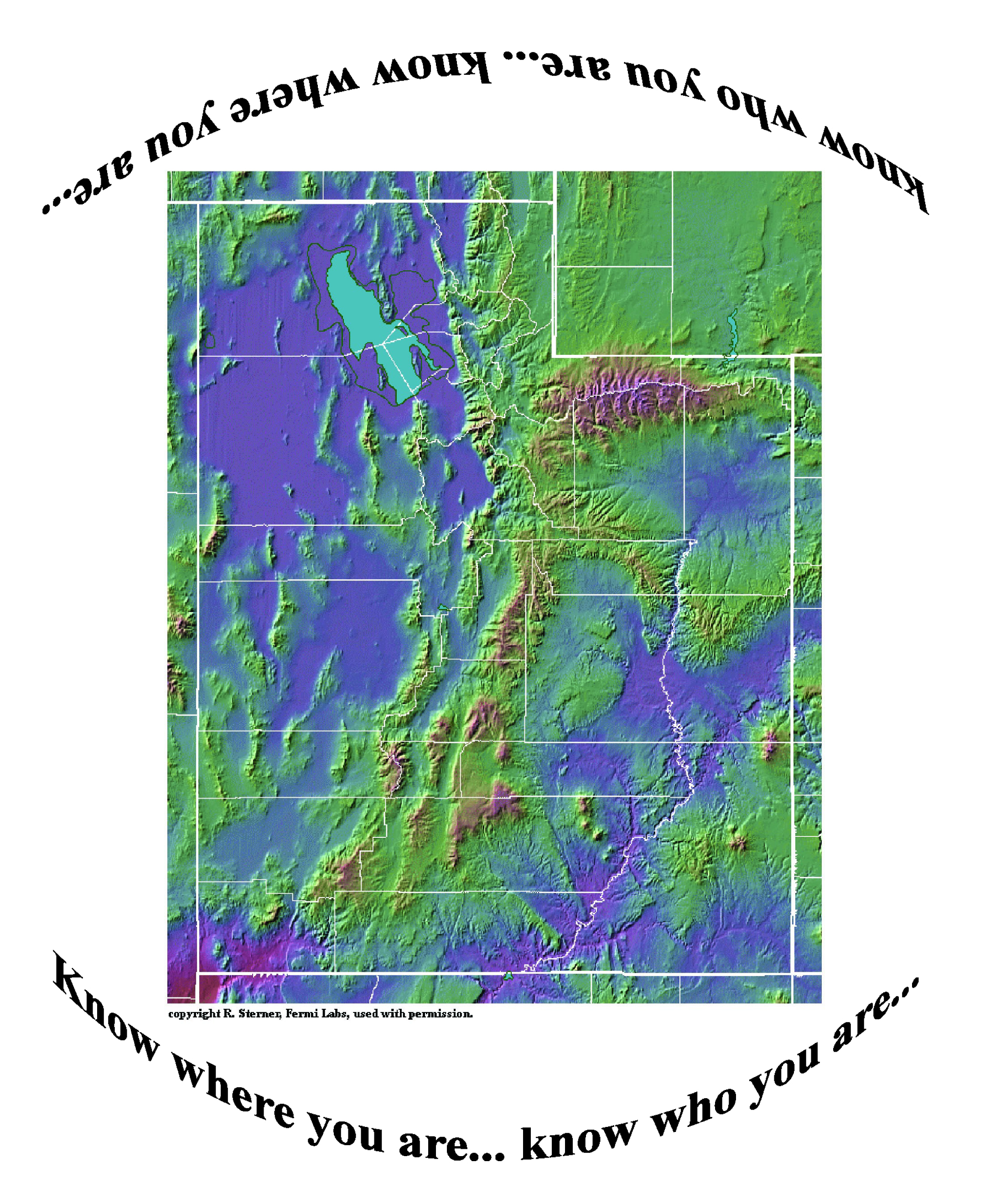
As always... become empowered by knowledge... of geography, of yourself: GEOG-Utah MantraImageSternerBase.